This blog provides information, stories, links and events relating to and promoting the history of the Wimmera district.
Any additional information, via Comments, is welcomed.


Showing posts with label homesteads. Show all posts

Tuesday, 22 May 2018

Final Fulham

Wimmera Mail Times Picture: Elijah Macchia
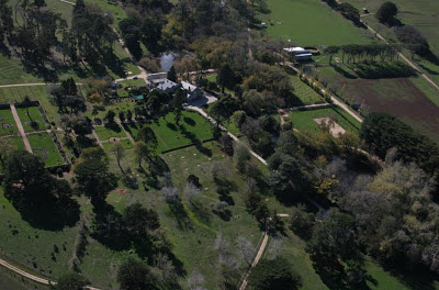
The Fulham Station homestead, at Kanagulk, was originally settled in 1840 by Francis Desailly. It was the first homestead to be settled in the Balmoral area.
Today, current owners Greg and Heather Walcott have the refurbished homestead on the station and its 65 acres (26.3hectares) on the market.
Greg & Heather (Wimmera Mail Times Picture: Elijah Macchia)
 The original landlord, Sir John Owen, may have never seen the land. He sold it privately to George Armytage and his family who established the buildings. The buildings date from 1846 and were progressively built after that.
In 1857 Fulham became the home for Charles Armytage and his wife Caroline. Eight of their 10 children were born at Fulham (50 miles from the nearest doctor). Fulham's remoteness encouraged them to purchase Como House in South Yarra as a town house in 1864.
The Armytages finally sold their Fulham and Mt Sturgeon properties in 1948, to the Soldier Settlement Commission, and the Commission developed Fulham Estate into settlement blocks.
 
Greg Walcott’s father successfully applied for the homestead block, and the homestead has been with the Walcott family ever since. Greg then inherited Fulham from his father and has spent almost his entire life living at the property.
Now they are moving on, and Fulham is looking for a new owner.
Wimmera Mail Times Picture: Elijah Macchia
Fulham Homestead was first listed with the National Trust in July 1965. Most of the heritage-listed buildings at Fulham have been built with ironstone. The stone is from within a kilometre of the homestead which was built on an ironstone shelf. The homestead is made from rubble-coursed ironstone with 2ft-thick walls, and contains two bedrooms, bathroom, living area, office and kitchen.
The Guesthouse
Along with the homestead building, there is a detached guesthouse featuring three bedrooms, two bathrooms, lounge and fully renovated kitchen, as well as a reading room with windows that frame an ancient Moreton Bay fig tree.
 
The tennis court & gardens (Wimmera Mail Times Picture: Elijah Macchia)
Greg and his wife Heather have developed the site - from the garden with sculptures Greg as created, along with a vegetable patch, a child’s play set under a tree and a lawn tennis court. “The garden was established when the property was built and then it was bulldozed. When (Heather and I) were married it was only a horse paddock, so we gradually re-established the garden in stages...there were a few established trees but very little else so eventually we have developed it right down to the water’s edge,” he said.
The garden slopes down to meet the Glenelg River at a broad bend. The property has its own watering hole finished with a bbq pit, wooden bench & table, an outdoor toilet, and a canoe landing stage.

The station cookhouse
The station cookhouse is one of the 10 heritage listed buildings which the Walcott’s have reinvigorated to a dining room with the original fireplace and stone oven still intact, now utilised as a wood-fired pizza oven.
Greg said moving away from this piece of 'living history' where he had spent almost 65 years of his life, would be a huge change.

Wimmera Mail Times interview video
If you have a spare $1.1 million- $1.2 million, then, Expressions of Interest close on Friday May 25 at 1pm.

Sunday, 19 November 2017

Solving the Wonnangatta mystery

The Wonnangatta murders occurred in late 1917 and in 1918, in the remote Wonnangatta Valley in the High Country in Victoria. The victims were manager of the Wonnangatta station property Jim Barclay, and John Bamford, a cook and general hand on Wonnangatta. While Barclay was a well-respected and much liked bushman, Bamford was regarded with suspicion, and was known to be easily roused into violent tempers. The case has never been solved, but many stories abound.
Wonnangatta Valley
To commemorate the 100th anniversary of the Wonnangatta murders, Horsham Branch are running a Criminal Investigation session on 10th January 2018
Each participant will receive a copy of one of the five published books relating to Wonnangatta and the murders, and their own “Wonnangatta Casebook”. They then need to read the story, and formulate their theory or theories. Then write up their thoughts in their casebook, thinking about any relevant -
* Clues
* Suspects
* A timeline
* Motives
* Facts

To test their hypothesis, all participants will meet with other contributors in a round table discussion on 10th January at 18:00 hours (6pm) in the Squad Room at Horsham Library.

Places are limited. Bookings are essential and must be made in person at the library to collect your books.

Wednesday, 22 March 2017

What happened...

Longerenong Homestead, when it was owned by Donna in 2010
"What happened to the camels of the Burke & Wills Expedition?" is the title of an article by Donna Bourke published in the Public Record Office Victoria's 'Provenance' magazine Issue 9.
From the homestead verandah overlooking the gardens, 2010
While she owned Longerenong Homestead, Donna Bourke became intrigued by the story of the camels that survived the expeditions of Burke and Wills, after discovering there was a link to Longerenong and Samuel Wilson.
Copy of Eugene von Guerard sketches of Longerenong c1868
The full article story is available online at the PROV's site and it includes a number of William Strutt's images.
There is more information on the camels during the Expedition at the Burke & Wills research archive and on the camels at Burke & Wills: Have camels will travel
For information on the expedition, check out the State Library of Victoria's Dig page

Cameler Dost Mahomet's grave near Menindee in N.S.W. >>

 Dost was a member of the Expedition's Depot Party, and afterwards stayed at Menindee to care for the sick camels

Tuesday, 21 June 2016

Such was life

This month the State Library’s “Our story : Such was life” is ‘The Mallee

In Victoria’s north-west lies the Mallee; a dry, hot region featuring sand dunes, salt bushes, shrubs and a ‘strange dwarf gum tree, Eucalyptus Dumosa, usually called Mallee…The tough land and climate certainly made an impression on Dr. Neumayer, a surveyor who recounted his experiences in 1864, ‘I can readily imagine why most people speak of this part of the country with a certain dread for there is actually no grass and no water to be found’…Over the years the land has endured its share of rural disasters, namely plagues (rabbits, mice, grass hoppers), drought and dust storms. Today its 100,000 occupants mainly reside in major towns like Mildura, Swan Hill and Kerang, but the Mallee is also dotted with smaller towns with delicious names such as Patchewollock, Cowangie, Boinka, Underbool, Piangil, Walpeup and Manangatang…In 1995 the State Library received a collection of photographs from the Rural Water Corporation (State Rivers & Water Supply Commission) which span the late 19th century to 1980. The thousands of images document Victoria’s water use and include many from the Mallee and Wimmera, which feature in this post.

Unfortunately some of the records have little or no information attached, they were grouped together under titles like:  [Wimmera - Mallee District] [picture], or [Wimmera region] [picture] with Accession no(s) RWP/1855; RWP/1870; RWP/1884; RWP/1883;RWP/1906; RWP/1862; RWP/1873; RWP/1926; RWP/1895; RWP/1932; RWP/1881; RWP/1878; RWP/1871; RWP/1872; RWP/1896; RWP/1923; RWP/1860

And Summary Descriptions: Shows sand drift on a Mallee farm, crops on Mr. Black's property, sheep at drinking storage at Dumosa, crops near Murtoa, ploughing at Murtoa, Miss Lodwick in her father's vegetable garden at Timberoo, interior of wheat storage shed in Murtoa, abandoned homestead at Galah, horses drinking from bore-water trough, Consolidated State School at Murrayville, bowling green at Ouyen, sand and crops at Patchewollock.
For some, it is easy to positively identify - for example the 'ploughing at Murtoa' can only be the 'RWP 1870' as the Stick Shed is visible in the background.
Ploughing at Murtoa (RWP 1870)
Likewise 'interior of wheat storage shed in Murtoa' is 'RWP 1884' a great shot of inside the Stick Shed.
Interior of wheat storage shed in Murtoa (RWP 1884)

 
Sand drift on a Mallee farm (RWP 1906)

It gets trickier with descriptions like 'abandoned homestead at Galah'. This is possibly 'RWP 1883' if you consider the building to look abandoned or derelict. Galah was a siding on the way to Walpeup.
Possibly abandoned homestead at Galah, it is RWP 1883

Another photograph which could be 'crops near Murtoa' or 'crops on Mr. Black's property' is 'RWP 1855'.  Mr Black's property was at Timberoo - north of Patchewollck and south east of Walpeup, and south west of Ouyen. Looking at the health of the crop and the vegetation in the background, it looks more like the Wimmera, than a really good year in the Mallee.

RWP 1855

From another catalogue record comes this graphic photograph, likely to be - 'wind erosion and sand drift at Patchewollock' and the gentleman, one of the commissioners - McClelland, Greenwood, Stafford, McNab, Fitzgerald, Hall, Rogerson, Welch, Godkin or East. It was taken during Royal Commission on Water Supply in 1936.
RWP 589


Thursday, 6 November 2014

Wot's in a name

What is in a name, its spelling, its pronuncation or its meaning, and how do these change over time?
The original gateway to North Brighton (the posts are over 5' high)
While out touring on the weekend there was some lively discussion as we drove along Mokepilly Road near Kewell - on how it was the same spelling as the other Mokepilly near Stawell.
Sure that it was Muck rather than Moke originally, I couldn't let it rest, so cranked up the PC to check out the Duffy map (PROVs online version of The 1862 Duffy Land Act map) fairly sure it included Muckpilly as an out-station of the Kewell Station. I was half right, the out station was "Muckbilly". 
Kewell Station was named as "Kewell or Muckbilly" and "Kewell & Muckbilly", it was settled by the Wilson brothers John & Alexander in April 1845.
And in fact the Mokepilly of Lexington Station is also spelt Mokepille in some sources.
The other bone of contention was the correct pronunciation of Darlot (of James Monckton Darlot fame) was it the French "dar-low" as with Darlot Swamp or the more common vernacular "dar-lot" as with Darlot Street. I think it is the old-timers who like to use some class and refer to the original dar-low while the lazier Aussie speech is sounding more a chopped-off dar-let.
Darlot settled Brighton with Archibald McLachlan in July 1843. It was subdivided into North and South Brighton in 1859.
The tour included a number of historically significant sites - the Kewell area, the entrance to North Brighton, and the remains of the Dooen Weir on the Wimmera River. 
Looking downstream of the Dooen Weir

Wednesday, 3 September 2014

What's on the For Sale sign?

Historic property Kout Narin is for sale. An interesting aspect is the variant spellings of Kout Narin, from - Koot Narin, Koot Nareen, Kout Norien, Court Nahring, and the homestead area as Second Kout Narin.
The homestead in 1980, from the National Trust
Kout Narin on the banks of the Glenelg River near Harrow was originally taken up in 1840 by Thomas Norris as a 400,000 acre pastoral run. This was one of the largest of the early pastoral holdings in the colony at Port Phillip.
Edward Willis & Charles Lambert Swanston (Charles’ father and Edward’s father-in-law was Captain Charles Swanston a colonial merchant and banker after whom Swanston Street in Melbourne was named) acquired Kout Narin station in October 1846 as ‘The Glenelg River Grazing Company’. Later in April 1848 they subdivided it into Kout Narin and Kadnook. (Kadnook was subdivided into Kadnook and Buckle Kupple in August 1857, then Kadnook further broken up into Kadnook and Tallangour in August 1864, Tallangour was divided into Tallangour and Lake Paddock in April 1874.) Kout Narin was further subdivided in September 1852 into Chetwynd and Pigeon Ponds (Moree) and again in September 1859 divided into Chetwynd, Mooree (or Pigeon Ponds), Koolomurt and Wellat(t). Willis and Swanston retained a part known as Koolomurt in 1859. Swanston kept Mooree in 1859. At Koolomurt, Willis formed one of the finest merino studs in Victoria. 
The Woolshed above Salt Creek, 1974 from SLV
Second Kout Narin was part of the original Rickett’s Run or Longlands. It was first occupied in April 1840 as ‘The Glenelg Sheep Establishment’. Thomas Rickett occupied it from 1843. Ricketts Run was broken up into Clunie, Longlands and Second Kout Narin. Second Kout Narin was on the right bank of the Glenelg. A two-room slab house with a shingle roof was erected in 1846.
The original slab cottage in 1980, from the National Trust
 In 1855 Richard Brown Broughton leased Kout Narin Station from Thomas Hamilton, where he subsequently erected the woolshed and the colonial homestead, integrating the early stone house of c1848. Broughton got the freehold for the Second Kout Narin property in June 1863. He changed the name from Kout Narin to Kout Norien.
From the curving driveway towards the rectangular house with a shallow flight of steps leading up to verandah, past garden beds, taken by an unknown photographer some time during the 1960s, copyright is undetermined, from SLV
 The early colonial style rectangular plan homestead of brick and stone with distinctive roof form, glazed verandah and colonial regency details was built in 1855 with the second storey portion added at a later date. The stone was quarried on the property. The homestead was placed on the Victorian Heritage Register in 1959, and the outbuildings added in 1980.
The stone-rubble stables with latticed openings, 1980 from the National Trust
The stone-rubble cookhouse, 1980 from the National Trust
Enclosed homestead verandah


The associated outbuildings, slab hut and slab woolshed, form an important pastoral station group, and are examples of early vernacular construction methods.


The following set of photographs was taken by John Collins in the 1970s, and are from the J.T. Collins Collection, La Trobe Picture Collection, State Library of Victoria.

The homestead
The homestead showing the quoins around the doors
The timber slab woolshed and its split picket sheep yards with the pickets wired together. Although dilapidated the woolshed is still in use.

The stone-rubble cookhouse and adjacent meat-house
Kout Narin is to be auctioned on Friday 12th September in Hamilton and is expected to reach $1.3-1.5 million.

Saturday, 1 February 2014

History in flames

The bushfire known as the Grampians, Northern Complex which raced through the northern sections of the national park and surrounding communities has left a trail of heartache as families have lost their homes, a life has been lost, hundreds of animals - stock and native fauna died or had to be shot, and acres of farm and bushland has been left a scorched husk.

Amid the devastation are a number of historic items now lost forever, notably the historic Rosebrook homestead, the building had been home to seven generations of the Carter family since 1858.
GONE: Rosebrook homestead in flames last week.
Rosebrook ablaze, from the Wimmera Mail Times
At the Grampians Horse Riding Adventures and Grampians Motor Museum, situated on Schmidt's Road, a number of the historic vehicles caught fire.

Fire glazed ute cabin, from Lynton Brown
Near Brimpaen this old 1800s farmhouse was burnt to the ground, luckily Lynton Brown had captured it in July last year, here is his 'then & now' image.

Brimpaen farmhouse, from Lynton Brown
We are yet to see the level of damage to the Zumsteins cottages, but they along with some of Walter's trees have been damaged.
Signs at Old Dadswells Town
There were close calls and as the media is reporting, parts of the area are now open for business and in need of support.
The edge of the fire at the entrance to Orchid Lane Cottages

Saturday, 8 June 2013

Stately homes too

When I was trawling the Net for information on the Bishop's Palace, I came across a reference to the sale of the historic Ercildoune.
Thomas Livingstone-Learmonth (1783-1869), a strict Presbyterian, was a merchant in Edinburgh, Scotland who made a great deal of money in the service of the British East India Company. Thomas was a merchant in Hobart, Tasmania in 1835 with his four sons John, Thomas Jnr., Somerville and Andrew. Thomas and Somerville were still in their teens when they were sent by their father to Victoria to find suitable sheep farming land. Leaders in the pastoral settlement of the Port Phillip district, they first settled at the head of the Barwon River, Geelong, and then at Buninyong followed by Burrumbeet in 1838. In 1849 Ercildoun was licensed in the names of John, Thomas Junior and Somerville. Erection of the house started in 1840 and additions added until it was finally completed in 1858-59.
The home and gardens from the air
Ercildoun became one of the more famous stately properties in rural Victoria. The Scottish baronial homestead with gabled wings and crow stepped and castellated parapets, was built of granite hewn from the slopes of Mount Ercildoun and handmade bricks from a kiln on the property.
Set on 73 hectares the two-storey homestead comprises nine bedrooms and three bathrooms, and features a ballroom and a library. A self-contained three-bedroom residence in the former maid's quarters is at the rear of the homestead. 22 houses were built on the property for 64 men and their families with its own school and gaol.
The Learmonths were also outstanding gardeners and created a network of paths and cultivated garden beds including oaks, elms, poplars, chestnuts and plane trees in pots brought from Scotland. They were leaders in the use of machinery with threshing and winnowing machines and had a flour mill powered by a water-mill which ground their wheat.
The main door with the 1838 keystone

The Learmonth family history dates back to the 13th century. Ercildoune has a copy of the tower or keep situated in the Borders region of Scotland to the west of the homestead. They apparently brought back to Ercildoun a stone from this keep and it was inscribed and placed in to the replica built here: ‘Stone from Rhymer’s Tower at Earlston, Scotland, occupied in the 13th century by Thomas the Rhymer’ whose direct line is Mary Livingstone a favourite maid of Mary Queen of Scots and the African explorer.
Thomas eventually married and sadly a daughter died at only a few weeks of age in 1858 and she is buried in the Ercildoun Cemetery that closed for interments in 1895.
In 1873 the Learmonths sold the station to Sir Samuel Wilson on a walk-in walk-out basis. Sir Samuel with his brothers - John and Charles, had bought Longerenong in 1856. He created an irrigation system that became the forerunner of today’s Mallee-Wimmera water gravitation scheme. He established a Sambar deer park on Mount Ercildoune and released chital deer into the Wimmera in the 1860’s from his Longerenong property.
The ballroom with the balcony in the ceiling
The ballroom's balcony
Sir Samuel also added the letter ‘e’ to Ercildoune because he wanted an even number of letters on his gates. The garden was extended to 40 acres and the impressive 1 mile long carriage way planted out with pine trees. He built a 1 acre 10’ high walled garden modelled on similar gardens in England for the cultivation of tender plants and vegetables and built a massive glass curvilinear conservatory that unfortunately is no longer in existence. He may have added the back wing to the homestead, and is believed to have built the Gothic style Manager’s House above the lake. At the height of his residency there were 125 people employed including 13 gardeners.
A section of the walled gardens
Dame Nellie Melba leased Ercildoune in 1907 and had a tennis court built for her use.
Sir Alan Currie bought Ercildoune from the Estate of Sir Samuel in 1920-21., and Lady Currie carried on the property after Major Currie died in 1942, until she too passed away on 1962.
John and Christine Dever from Melbourne purchased the property in 1999, restored it and were looking to sell it for about $4 million in May this year.
(Historical information & photographs from the Ercildoune website