This blog provides information, stories, links and events relating to and promoting the history of the Wimmera district.
Any additional information, via Comments, is welcomed.


Showing posts with label Warracknabeal. Show all posts

Saturday, 7 January 2023

Locally on BorrowBox

 Local ebooks are available on BorrowBox.

The people at BorrowBox allow member libraries to add local content to their library's collection. Wimmera Libraries now have 3 locally produced ebooks on BorrowBox.

"Lost in the bush" In 1864 Isaac, Jane & Frank Duff became lost in the bush. Locals searched for the children for 9 days. This book is a day by day account of what happened on each of the 9 days, with information from contemporary articles and books.


"The fate of the Imperials"
 In 1914 the Warracknabeal Imperials decisively won the football premiership against Rupanyup. Within a month four players had joined the first local contingent to be sent off to fight in the First World War. In all fourteen of the players would enlist. This is the story of the fate of those Imperials, collected from local newspapers and their Service records.

An alphabetical listing of all the schools that have existed in the Wimmera and Southern Mallee districts. Entries include a brief history of the school, GPS coordinates and one or more photographs of the school or site.
The title comes from the fact that many of the now deserted and abandoned rural school sites are marked with trees planted by school children on Arbor Days and special occasions.
Primarily the variety of tree chosen was the sugar gum, though there are peppercorns, various cypress & pines, and ornamental deciduous trees. School gardens were also marked by large and small species of cacti & succulents, and annual bulbs - jonquils, daffodils and lilies.
Along with monumental plaques, these are often the only signs that schools have existed, and they stand as testament to the tenacity of the teachers, parents and children who attended these schools.

It is likely that more Wimmera stories may be added as local content.

Just like other ebooks in the BorrowBox collection, these books can be borrowed, so check out one today. 
Instructions for installing and using BorrowBox are available on the Library's website, if you haven't used ebooks previously.


Monday, 20 September 2021

Warracknabeal RIP

 Seriously impressed with the Warracknabeal Cemetery's deceased search functionality.

"Warracknabeal Cemetery Chronicle is an online digital mapping system which indicates the exact location of a gravesite by simply inserting a deceased name. It gives the plot details, date the person was buried, other people in the grave and shows where the plot is in the cemetery. 


 Eventually more burial details on each deceased person will be available on this system. It is helpful for family historians as it shows the exact location of the gravesite. It also assists cemetery administration as it readily indicates reserved, occupied, and vacant gravesites in the cemetery."

The Chronicle people say their software makes securely managing your cemetery easy and affordable by allowing you to 

  • Create your digital cemetery
  • Manage your interment register
  • Share with the community

and that it is free for small cemeteries (up to 1,000 plots)!

Other Victorian cemeteries using Chronicle (you can search) are Beechworth, Bendoc, Boort, Bunyip, Carlsruhe, Chiltern, Lang Lang, Macedon, Maddingley, Murchison, Ouyen, Phillip Island, Rosedale, Yan Yean & Yarram.


Monday, 18 July 2016

The Church, the Hotel, the Society


This week's curly question was: where did the name for the Blue Ribbon Road originate from?

It is the road runs north for over 50kms, from Horsham to its terminus at Fryatts Rd, near Willenabrina.
It passes through the Greenland Dam, Kalkee, Garup, Sailors Home, Murra Warra, Wallup, Cannum, Aubrey, and Crymelon localities.
Some maps call it the Horsham-Kalkee Rd, for the section to the Borung Highway at the Blue Ribbon Corner.

But why 'Blue Ribbon'? This is the question that no-one - long-time residents or historical societies - seem to have the answer for.
The best guess so far is from Marj, who believes it relates to the Temperance Movement.

The Temperance Movement was a social movement upholding the ideals of an alcohol-free lifestyle, through moderation or banning the consumption of alcoholic beverages. The Movement became more radical, advocating the legal prohibition of alcohol – teetotalism. It was particularly important and developed in the 19th and early 20th centuries. It saw temperance halls and coffee palaces as an alternative to hotels, they ran lectures and films upholding family values and discouraging drunkenness, successfully implementing early hotel closing times (6 o’clock swill) which didn’t lead to a curbing of consumption. The Movement’s role began being wound back in the 1950s and 1960s in more relaxed liberal times.
Members of the Temperance Society would take the Pledge to either become a teetotaller – a soldier of the Blue Ribbon Army, or the White Ribbon – for women of the Women's Christian Temperance Union.
The Society promoted alternatives to alcoholic drinks like ginger beer, creamy sodas, and sarsparilla, served in Temperance bars and coffee palaces. 
It also gave rise to the popularity of aerated waters and cordials, and led to the establishment of a number of localised cordial factories and manufacturers (whose old bottles are now rare collectors' items).
Callawadda's old cordial factory
 
In October 1883 the people of Cannum East met in the Wallup Free Church to establish a branch of the Blue Ribbon Army. Other branches sprang up in Clear Lake, Jung, Horsham, Rupanyup, Nurrabiel, Pimpinio, Kalkee, Warracknabeal, and other areas.
There was a close link between the Society and the local churches, often meetings were held in the church buildings. Both the Kalkee Wesleyan Church (built in 1885) and Wallup Presbyterian Church, faced the Blue Ribbon Road. The Wallup Presbyterian Church was first held in the Wallup State School, till a church was built across the Wallup Church Road in 1910. Anglican services were also held in the church in the 1930s and 40s. 
Wallup Presbyterian site 1910-1973 with the school site behind
Both the Cannum East (1875-1955) at the corner of Matheson & Antwerp Rds, and the South Cannum Presbyterian churches at the corner of Boundary & Cannum Church Rds were further east.

The Women's Christian Temperance Union water drinking fountain erected in 1911 in Warracknabeal. It was inscribed with the Union's motto: "For God, home and humanity". The fountain was given to the Borung Shire and originally located at the Town Hall. In 1939 it was transferred to Anzac Park (Photo I. Phillips).
 
So if people were against drinking, where were the hotels they were campaigning against?  
One would be the Blue Ribbon Hotel on the Blue Ribbon Corner. It was originally known as Patterson’s Wine Shanty, but by 1889 it was called the Blue Ribbon Hotel. 3 acres Allotment 68A in Wallup Parish was sold to Alexander Patterson on 5th January 1882. (The Pattersons owned a number of surrounding allotments). 

By 1884 the intersection was called 'Patterson's Corner'.

 The hotel was also a 'Post Office' from 1899 (a mail bag was dropped off there).
 
It was 'Patterson's Blue Ribbon Hotel' when it was destroyed by fire in April 1903. A new 5-room Blue Ribbon Hotel was erected, but it had its licence surrendered by December 1925, and then, on 12th January 1926, it again burnt to the ground, not to be resurrected again. 


"The HorshamTimes"  Friday 15th January 1926, page 6.

 
The site of the Blue Ribbon Hotel
It would be interesting to know how many participants at the 'Blue Ribbon Raceway' were aware of this conjecture?
We would be interested in hearing from anyone who could confirm or refute this hypothesis.

Thursday, 17 March 2016

Institutions crumble

Two  Wimmera institutions crumbled and were reduced to rumble this week.
The Church of Christ before demolition begins
Firstly the Horsham Church of Christ building. The church has stood on the corner of Firebrace and Urquhart Streets since 1918, and over the past fortnight has slowly been demolished. Watched and mourned by many as another Horsham heritage building succumbed to the reactive soils and progress. 
The building with its square tiers, mock buttresses and tiled roof was extended in 1957, but was considered no longer suitable for the congregation and will move to River Road. The old site will become a child care centre and townhouses.
Going...the tiles removed
Going...the rear extension gone

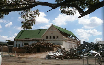
Further north in Warracknabeal the old hospital building is being torn apart as some of the buildings make way for the new Rural Northwest Health redevelopment.
The Warracknabeal Hospital
More than $10 million will be spent to build a new acute care and community care area, and refurbishment of the Landt & Banksia sections.The hospital opened in March 1891, and has steadily grown since.

Friday, 13 December 2013

Styling stations


This post grew from this comment -
"Can someone please elaborate on 'Bealiba style'? I was brought up in Bealiba and spent years hanging around the Bealiba Station but have never heard of the term. Thanks Brian H." on the earlier post ‘Railways - Mildura line’ and led to a little research at the State Library.

The 1870s was an era of railway building, that ended with the financial crash of the early 1890s, when railway lines were extended westward. During this period, the development of a succession of standard plans coincided with the patterns of railway construction, establishing groups of stations common to sections of line.
Bealiba in 1980 (Andrew Ward)

There developed a "line style", in which similarly-designed station buildings imparted their distinctive character along a particular line. The Bealiba station building was one in the “light line” style along one of the “main trunk” lines and gave its name to a prototype style which was an economic solution to the previously costly construction of railway station buildings.

According to Andrew Ward in a ‘Study of Historic Railway Buildings and Structures’ and 'Victoria's Railway Stations: An Architectural Survey', the Bealiba Style is an earlier sub-group of the Rosedale Style. He says the Rosedale style developed in response to the need to save on construction costs,and was the first design to be widely employed for all-timber type buildings. In all, 12 Rosedale style buildings were erected (Cope Cope was the only example in this district) and 6 in the earlier Bealiba Style of station building - Bealiba, Broadmeadows, Euroa, Kilmore East, Lubeck, Murtoa and Wallan.
Lubeck in 1981 (from VRnet)
Constructed in 1878, the Bealiba building is still substantially intact as an example of the style. Elements of the Bealiba Style are: An oblong single-storey plan timber construction with bisecting longitudinal corridor which terminated at a porch. The combined station and residence had a verandah to the platform formed by an extension from the main roof. Four rooms were residential (2 bedrooms, parlour& kitchen) and 2 for railway purposes – the Booking Office and the Ladies Waiting Room. The 4 corner rooms all had fireplaces. The lamp room & toilets were all in the station yard. Copying the diminutive Dooen Style, the barge boards were fringed with cast-iron lace-work, and ornamental brackets adorned the porches. The verandah post capitals, gable vents and finials all had decorative timber work. The interior walls & ceilings, and lamp room & toilets were lined with tongue & groove boards.
Plan of the Bealiba building (Andrew Ward)

The later Rosedale style omitted the cast-iron lace-work, the end porches and 2 fireplaces, but now included a General Waiting Room.

Other stations in the area awarded a “style” are:

·     The "St. Arnaud style" (1879) comprised an architectural symmetrical single-storey hip roofed brick station with cast-iron platform verandah and pavilions and a standard U shaped plan for the station building. It is the most intact example of the largest standard station building design erected on the early light lines.

St Arnaud's water tower

Also the St Arnaud water tower was built as a standard 'Type B2' hemispherical design carried by a 'T' iron frame and installed onto a cement rendered brick column. It is the last remaining example of this construction, with other B2 type towers originally located at Cranbourne, Bealiba and some metropolitan locations.

Diapur station building in 1971 (from "VR stations & stopping places")

·     The “Kaniva Style” which in addition to Kaniva itself, included Diapur, Leeor (to Melton), Miram and Nhill. Small timber buildings with classical decoration & gables.

The ornate platform verandah, Minyip

·     The “Minyip Style” used for Minyip and Yarra Junction.

·     The “Rupanyup Style” used at Rupanyup and Bairnsdale

Past glories - the dilapidated Rupanyup building

A “Special Design” was used for Serviceton, Warracknabeal (1887) was built in the “Casterton Style” a Tudor/Late Victorian look, while Dimboola (1882) is in the “South Melbourne Style” the Italianate/Late Victorian style.

The same style - Donald & Birchip


Wednesday, 26 June 2013

Blackboards to battlefields

It is great to see that local groups are applying for grants from the government's Anzac Centenary Program to commemorate the 100 year anniversary of Australia's involvement in the First World War (see my post of 8 June 2012).
The Warracknabeal Historical Society is looking to locate all the Honour Boards from local schools and collate all their information into a database. A seriously involved operation when you realise that most of the local rural schools no longer exist and it will be a detective job to research who may have inherited the boards (and shudder with the thought that some may no longer exist).

On the subject of school honour boards and teachers & ex-students serving in World War I is a new book - 'Our schools and the war' by Rosalie Triolo.

The Great War profoundly touched the lives of Australian teachers, school children and local communities, and with lasting consequences. Every teacher had the task of explaining the war to their students. Many teachers, a disproportionately large number, fought and died, and were joined by their older students. For years after, the names of those who fell were respectfully displayed on school honor boards, in honor books and remembered by other commemorative means, including through the introduction of Anzac Day. 
How teachers and school communities were affected by patriotic appeals and activities, and how they responded to the long years of grim news from Gallipoli, the Western Front and other sites of training, fighting and convalescence, is revealed in an account that historians, general readers and today’s students will find illuminating and deeply moving. 
Many of the contributions to the book come from Norman Heathcote a school teacher who joined up  in July 1915, when he was 28, and wrote about his experiences and about teachers, trainees and pupils he knew on active service from schools where he'd taught. He was a quartermaster during the war, he sailed with fellow teacher-soldier Lance-Corporal Henry Pender of Dadswells Bridge. After the war he became a School Inspector in 1924. He was the President of the Nhill RSL in 1921.

A wonderfully fascinating account from the book concerns a Ni Ni East teacher who arranged for a pair of socks to be knitted for General W.R. Birdwood (he was the commander of the Australian forces at Gallipoli), and as a fund-raiser, a charge was made for the privilege of knitting a row. The General replied that it "is really wonderful that your school, with only 10 pupils, has been able to build up a fund of 50 pounds".
If you know the location of a school honour board, the Society would love to hear from you.

Sunday, 20 January 2013

Railways - Patchewollock line

A Patche bound steam train at Warrack (from "C.R.S.V.")
The Patchewollock line branched from Murtoa, efforts to extend the line were due in a large part to the lobbying of pastoralist Edward H. Lascelles. He started construction of the private line, but it was completed by Victorian Railways. The line was changed from broad to standard gauge at the same time as the main line to South Australia. The line beyond Hopetoun was closed in December 1986 and the tracks removed.

Coromby's weighbridge scales still in situ
Coromby Grain has always been an important component of the Patche line, in fact all the rail-lines in the Wimmera. Though Coromby's silos are now disused, evidence of that grain cartage still remains, including its weighbridge manufactured by Hawke & Co of Kapunda in South Australia (Henry Binney Hawke established the H.B. Hawke iron foundry and engineering works in 1857, and created the first hydraulic car hoist, the broadcast seed sowing machine and the weighbridge. The company closed in 1983).

Minyip station and sheds (from "C.R.S.V.")
The first train steamed into Minyip in January 1886, but the station was not officially opened until May with a daily passenger service. Stock yards were erected in 1887, the goods platform extended in 1888, and a weighbridge and Diary Produce shed added in 1889. The tender for construction of the station building was let in 1890.When built in 1939, the silos were largest capacity in Victoria. A steel annex bin and oat shed were erected in the 1950s, and a 250,000 bushel bulkhead in 1969. In 1976 a road bus replaced the passenger rail-motor and by the mid 1980s the stock yards and goods shed were demolished. The classic boarded-up station and platform still remains.
The Minyip station building
Nullan
The symmetry of the Nullan silos
Originally known as Tarkedia, the name was changed to Sheep Hills in 1886, when the railway arrived and a township grew up around the station. The station was a brick building with a cool storage chamber.
The Sheep Hills siding with the main line on the right
The now abandoned Warracknabeal building
Warracknabeal the line from Murtoa reached Warracknabeal in May 1886. Now the disused red brick station building and passenger platform remain. The extension of the line northwards was orginally known as the Warracknabeal-Lake Corrong Railway Line.
Warracknabeal Station (from "C.R.S.V.")
Warrackside is still a major grain siding, a kilometer north of the Warracknabeal station, part of the facilities are a large silo and an old distillery grain storage. Below the Warrackside line branches from the main Patche line. Some of the silos are visible along with the large bunker sites in blue tarps.

Batchica Siding work to extend the line beyond Warracknabeal began in February 1892, at a time when the Mallee wilderness was being opened up to farming.


Lah A variety of silo styles sit on the plain surrounding Lah.


The line opened to Brim in January 1893 (the township wasn't surveyed until 1890). The station handled grain and stock and had a passenger service, now only the grain traffic remains. The grain shed constructed in 1894 was also used for community functions. The silos were constructed in 1938.
The Goods Shed at Brim
Brim Gangers quarters with an extra 2 room extension, shifted to Wardle's 'Klondyke' farm on the back of Keith Hunter's truck in the early 1970s
Galaquil station was located on the division between the Wimmera and Mallee, and it also served as the town Post Office (the postal boxes are visible below the Galaquil sign in the photo below) until the closure of passenger services in July 1976.
Galaquil in 1971 (from "V.R stations & stopping places")
Beulah The rail line reached Beulah in June 1892, and officially opened in March 1893. A second railway station building erected in 1910 was destroyed by fire in April 1928. A rail motor passenger service from Murtoa commenced in 1926, the last passenger train was in July 1976. The Beulah ticketing office is now used as a club meeting room.
A crowd of passengers await the train on the Beulah platform, 1986 (from "C.R.S.V.")
In contrast - the deserted Beulah station in 2009
Beulah's cement silos were built in 1939, and the 1 million bushel silo complex opened in 1963. Beulah GEB Siding while there is no longer a Beulah passenger service, the grain silos and bunkers are still operational.


Rosebery passenger services stopped in 1961, but the siding & silos remained. The silos are opposite the old church building which is now the Outback Cafe.


Goyura residents petitioned for the line to deviate to the township, and a siding was approved.

Hopetoun the first steam locomotive reached Hopetoun in December 1893, and the Beulah-Hopetoun section was officially opened on April 11 1894. The rail motor passenger services from Murtoa began in 1934 and ceased in July 1976. Hopetoun is again the terminus of the line. The passenger station building has been removed leaving only the silos and goods shed.
Hopetoun's goods shed from the platform mound
Burroin siding closed in 1953.
Dattuck siding closed in 1955. (below) J542 locomotive on the broad plains between Hopetoun and Dattuck with goods for Patchewollock, in December 1966
J542 near Dattuck (from "Patterns of steam")
Today, Yarto has more than the appearance of isolation, at the end of a 'no through road' backing onto the sandhills of the Big Desert and Wyperfeld National Park.

The 200 tonne silo at Yarto
Willa siding closed in 1953, today Willa is surrounded by encroaching mallee, and the faded sign is the only evidence of the 'Willa Railway Station'.


A forlorn looking Patche station
Patchewollock construction of the 27 mile line extension to Patche began in September 1923, and terminated 2 miles short of the town. It was officially opened in May 1925. The galvanised iron goods shed was erected in1928. A weekly goods train service ceased in September 1975. The 1925 weighbridge was computerised in 1985. The line closed in December 1986 and the rails were ripped up, but the small weatherboard station building and goods shed were left. The silos are still in operation.
J542 again, approaching a sand fence shortly after leaving Patchewollock in 1967 (from "Patterns of steam")
Further information and photographs at Shane McCarthy's "Patterns of steam" and Neville Gee's "VR stations and stopping places" and John Sargent's "Country railway stations Victoria" series