This blog provides information, stories, links and events relating to and promoting the history of the Wimmera district.
Any additional information, via Comments, is welcomed.


Showing posts with label Bushfires. Show all posts

Tuesday, 13 February 2024

Grampians fires ... again

 'Tis the season again for bushfires, with two fires in the Grampians - one at Mt Staplyton & the other near Bellfield. Begun by lightning strikes on Tuesday morning, they were fanned by strong gusty winds all through the afternoon.

Lynton Brown captured the scene from Taylors Lake, the image showing the smoke from the fire between Mt Difficult (the high range & bluff at the back) and Mt Staplyton ridgeline in front, with the choppy yellow-tinged waters of the lake in the foreground.
Lynton Brown's telephoto view from Taylors Lake 5:15pm
The Western Highway was closed as the fire approached Dadswells before jumping the road and heading towards Glenorchy, and it remains closed today from Horsham to Ballarat, with huge detours via either the Sunraysia or Henty or Wimmera Highways.

Five CFA firefighters sustained minor injuries after their truck was involved in a burnover while fighting the fire & protecting homes at Pomonal.


Lynton captured the scene at 9:30pm on 13th, from St Helens Plains. It is looking South towards North-east part of the Grampians and to the left as far as Glenorchy.

As always thanks & gratitude to the efforts of Lynton Brown out & about recording these events. And thinking of those involved - firefighters & landowners, etc.

Wednesday, 24 January 2018

From Dimb to Basalt Knob

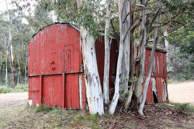
A retired railway carriage from Dimboola has ended up in the mountains of the Victorian High Country.
The T 101 icewagon railway carriage hut aka Basalt Knob Hut, was built in 1894 at the Pinder & Kelly Newport workshops for the Victorian Railways and de-registered in 1978. In the early 1980s a Dargo timber mill purchased the rolling stock from the Dimboola line for forestry workers accommodation and trucked them to Dargo. 
The carriage was in a Dargo mill when it was bought by Ken Scott from David Coates, who sold it to David Eddy from Deeandal & Sons logging company. 
A logging road was constructed, and a loggers' camp erected at Basalt Knob in 1982. The T 101 icewagon was carted it up to its location up above Talbotville near Blue Rag. When the logging finished all the other carriages forming the logging camp were removed by the mill, but they never got around to removing the T 101 carriage, so T 101 now ‘The Basalt Knob Hut’ is still there offering emergency shelter in the Victorian High Country, at Basalt Knob near the junction of Brewery Creek Track & Ritchie Rd which can be accessed via the Dargo High Plains Rd.
Story and photos from the Victorian High Country Huts Association Facebook page

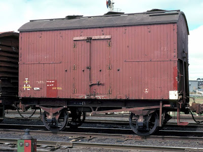
 Hauled by steam diesel powered locomotives, the ‘T’ insulated ice van carriages had an ice bunker running along the middle of the ceiling that was filled with ice from hatches in the roof. Used to transport refrigerated meat carcasses or other goods that required a cool temperature, their walls were between 4 & 6 inches thick for insulation. The vertical channel at the end was a drain for the ice bunker. All T's in this number group had lever type handbrakes. This series of T vans had a 12 ton capacity. A relic from a bygone age they lasted to the late 70's in "refrigerated" service. (from Victorian Railways Net)


An update: a photo of T 101 while still on the rails in 1978, possibly in Dimboola, from rail-fan Geoff Winkler who took photos in the Wimmera in the 70s.
A further update: unfortunately T 101/Basalt Knob Hut was lost in the January 2020 bushfires.
Photo: Brendan Brooker, from VHCHA Facebook page


Wednesday, 7 January 2015

Fire all around

Kadnook fire - B & B Ryan
As smoke envelopes much of the Wimmera, we find a number of bushfires raging across the district once again. Many of the fires reported to be as a result of thunderstorm lightning strikes on Saturday 3rd and Wednesday 7th.
Moyston fire from Bunjil's Cave Rd on 2nd - Lynton Brown
Moyston by night - Keith Pakenham CFA
 The fastest moving blaze was the one to the east of the region at Moyston. The 3,500+ hectare fire had a 64km perimeter with 250 men battling it on the ground and in the air. It may have been ignited by a scare gun operating on a vineyard, before it raced across paddocks to the outskirts of town. In the end 2 houses and a number of sheds were lost as well as about 3,000 sheep. A great report is from Leith Hillard’s report of the Moyston Fire.
Fighting the Moyston fire, from One Tree Hill, Ararat - Lynton Brown
 
Ominous, the giant plume over Telangatuk East, from Horsham - Lynton
The Black Range looking west from the Grampians at 6:30pm - Facebook
The other major fire is the Black Range-Rees Rd (Telangatuk East) fire which started in the mountains on Saturday 3rd and moved north into the Mt Talbot Reserve then broke out again to the south towards Cherrypool. It is currently over 4,500 hectares and NYUC. (all Telangatuk photos were taken late on Monday 5th, when a tongue of fire spread north)

Above & below: Mt Talbot at dusk - Lynton Brown

In the Little Desert there is a whole list of fires, most are NYUC - Not yet under control

- Lillimur Track (Booroopki) started on the 7th has burnt 1800 hectares
- Serviceton started on 3rd 505 hectares
- Nhill-Harrow Rd started on 7th already burnt 13,300 hectares
- Miram South (Broughtons Track) from the 3rd has burnt 3,175 hectares
- south of Woriagworm 1,100 hectares
- and smaller ones on Salt Lake Track, Wallaby Track, Mallee Track, and Dahlensburg Track.
Smoke from the Little Desert obscures Mt Arapiles, from the Grass Flat Rd, 7th - Lynton
Majorlock Soak, Big Desert - CFA
Further north in the Big Desert there are fires in the Sunset Country and further south at Waggon Flat (north of Yanac and Broken Bucket) it has burnt  727 hectares. As well as the Chinaman Well Track of 600 hectares, again NYUC.
Majorlock Soak, Big Desert - CFA
Eruption of the Kadnook fire, from west of Edenhope - B & B Ryan
In the west
- Edenhope-Johnsons Rd (Kadnook) Fire started by lightning in the Jallakar State Forest and spread up to the Scrubby Lake area.The fire grew to approximately 1,600 hectares in size, now contained.

Kadnook fire takes off north - B & B Ryan

- Ozenkadnook fire in Bulls State Forest has subsided after burning 60 hectares.
Near Scrubby Lake - B & B Ryan
On Wednesday 7th in the Grampians - northern district a fire started near Wartook, and in the southern district near Mirranatwa.
Police roadblock - B & B Ryan
As always thanks & gratitude to the efforts of Lynton Brown to graphically record these events. And thinking of those involved - firefighters & landowners, etc.

Friday, 4 July 2014

Trees falling in the forest

Zumsteins Picnic Ground was one of the locations that were affected by the Grampians bushfire in January this year.

A spruce prior to the fires
Now the National Parks people have confirmed that rangers will remove 80 pine trees, 27 of them at Zumsteins. The trees, nearly 100 years old bore the brunt of the fires which swept through the area. Planted in the 1920s they are part of the heritage of Walter Zumstein. Between 1934-35 Walter & Jean Zumstein built pise (rammed earth/clay) cottages using local earth and stone, and second-hand building materials. Walter was sympathetic to the environment and planted 100s of both rare native and exotic trees.

Radiata pines at the picnic ground


National Parks plan to replant with ornamental species which reflect the historic nature of the area.
Zumsteins Picnic Area and McKenzie Falls are both still closed to the public after the fire damage. Other sections of the National Park have been reopened, with Parks staff monitoring conditions during the wet months.

Friday, 14 February 2014

All clear for the Mallee

A postcript to my initial post on the fires north and south.
A message from the CFA yesterday, announced - "The final ALL CLEAR has been issued this week for the Mallee fires that started nearly a month ago. Lightning sparked 18 fires on the night of 14 January, and since then more than 110,000 hectares have been burnt". 
Fighting the fires has been hard work for all involved - the firefighters, the allied organisations, the shires, and the communities. While other fires came and captured the news headlines, these communities battled on.
CFA photo from the Mallee
To everyone, thanks for your efforts, and looking forward to All Clears for the other bushfires too.

Saturday, 1 February 2014

History in flames

The bushfire known as the Grampians, Northern Complex which raced through the northern sections of the national park and surrounding communities has left a trail of heartache as families have lost their homes, a life has been lost, hundreds of animals - stock and native fauna died or had to be shot, and acres of farm and bushland has been left a scorched husk.

Amid the devastation are a number of historic items now lost forever, notably the historic Rosebrook homestead, the building had been home to seven generations of the Carter family since 1858.
GONE: Rosebrook homestead in flames last week.
Rosebrook ablaze, from the Wimmera Mail Times
At the Grampians Horse Riding Adventures and Grampians Motor Museum, situated on Schmidt's Road, a number of the historic vehicles caught fire.

Fire glazed ute cabin, from Lynton Brown
Near Brimpaen this old 1800s farmhouse was burnt to the ground, luckily Lynton Brown had captured it in July last year, here is his 'then & now' image.

Brimpaen farmhouse, from Lynton Brown
We are yet to see the level of damage to the Zumsteins cottages, but they along with some of Walter's trees have been damaged.
Signs at Old Dadswells Town
There were close calls and as the media is reporting, parts of the area are now open for business and in need of support.
The edge of the fire at the entrance to Orchid Lane Cottages

Wednesday, 15 January 2014

Bushfires north & south

Unfortunately it's time once again to depict bushfires in the local area. This time it is again fires in the Grampians, but also fires to the north (Yaapeet) and north-west (Yanac).
Again we are fortunate to have Lynton Brown photographing fires at the opposite extremes of the region.
Lake Albacutya fire Tuesday
Lake Albacutya fire Tuesday night
Firstly he was at the Lake Albacutya (Yaapeet, Nypo, Hopetoun West) fire on the 14th & 15th, and is now at the Northern Grampians (Halls Gap, Roses Gap) fire.
Albacutya fire Wednesday
Smoke from the Albacutya fire, 15th
Tankers at Yaapeet on Wednesday
Checking on the CFA site today the Lake Albacutya fire has burnt 10,700 hectares, there are a number of other Mallee fires in the Wyperfeld National Park and near Tempy, as well as the Big Desert fire north of Yanac which has burnt 2,881 hectares.
The main Grampians fire (there's another outbreak in the Black Range near Bunjil's Cave, and and in the southern area near Mt Victory) near Polhners Road is also out of control burning in rocky terrain between Roses Gap and Wartook. Lynton has managed to capture these photos on his phone.
Smoke from the Northern Grampians fire 16th
Approaching the Northern Grampians fire, Thursday

Wednesday, 23 January 2013

Fiery photos

In all the furore of natural disasters, it is easy sometimes for the event to hit the headlines everywhere, but only till the next 'big thing' comes along. Also in this instant and constant stream of information it is easy for ephemeral and items of a transient nature to be forgotten or lose details. Thanks to modern technology, and the efforts of people like Lynton Brown, these events are recorded. The following is from the Karnak fire on 8.1.2013.

Apparently the fire started about 3pm from a disused windmill on a property at Karnak, 15km south-east of Goroke, and with the strong winds fanning the blaze quickly swept north-east through the Kalingur State Forest, into private farm land heading towards Gymbowen. 

Winds gusted up to 50kph during the late afternoon, and police were forced to construct road blocks on a number of roads. Later a helicopter with an FLIR (Forward Looking Infra-Red) camera was used to check for hot-spots. This was the first time the new technology was utilised in the Wimmera. In the end, the fire burnt approximately 920 hectares of forest and grassland.

Sometimes there may be a commemorative book - 'Beyond the smoke : fire, destruction and images of hope' from the 2006 Grampians fire, and 'The Remlaw Fire : our stories from Black Saturday' the fire around Horsham in 2009. But the smaller outbreaks don't warrant the same coverage or notoriety and can fade into oblivion, remembered only by those directly affected.


Now, private and commercial photographs and videos form important historical artifacts, part of the story of this region. It is vital to archive these vinaigrettes, be it on your hard-drive, photo album, Flickr or Facebook, etc.