This blog provides information, stories, links and events relating to and promoting the history of the Wimmera district.
Any additional information, via Comments, is welcomed.


Showing posts with label Railway stations. Show all posts

Wednesday, 11 April 2018

Planes, Trains and Fuel Tanks

The Wimmera Branch of the National Trust is organising a special bus tour as part of the Australian Heritage Festival.
Serviceton Railway Station
Visit and tour the historic Serviceton Railway Station, the Nhill Airfield and Wolseley Fuel Tanks by coach from Horsham.
The Wimmera Branch will host a special coach trip leaving the Horsham Library car park to travel to Nhill, Wolseley, Mundulla and Serviceton. Representatives from each stop-over will meet and greet the visitors.

At the Nhill Aviation Heritage Centre. The Centre has a Avro Anson, Link Trainer and Tiger Moth, and is fundraising for a Wirraway. See the current restoration projects while partaking of a refreshing morning tea.

Water tower, Sericeton
Crossing the border into South Australia, view the Wolseley Fuel Tanks which were camouflaged as farm buildings. In WWII fuel storage depots were erected at various inland sites considered secure from attack by sea-borne aircraft. At Wolseley two standard 120,000 gallon storage tanks and one 40,000 gallon ethyl mixing tank were erected & camouflaged to look like farm buildings with broom bush and straw.

Take in lunch at the historic 1884 Mundulla Hotel for their seasonal menu (at additional cost), or BYO picnic hamper in the park opposite the hotel.

Back in Victoria, tour the once-grand 1887 Serviceton Railway Station. Built on the border between Victoria and South Australia, Serviceton served as both the changeover point for the different railway gauges and Customs Control between states until Federation in 1901.

Serivceton Railway Station Yards, T. Payne
Serviceton, close to the Victoria-South Australia border, was the changeover point for locomotives and crews on the broad-gauge system until through-running was introduced between Melbourne and Adelaide. Thus a variety of motive-power and rolling stock from both state-systems could be expected there at any one time. In more recent years this line has been converted to standard-gauge; most of the facilities seen in this photograph are but a memory and trains no longer stop there.  Taken on 2 December 1967 by Ted Payne (from “Closed station - Lost Locations Victoria part 2” Train Hobby Publications).

This amazing photograph shows the station at a time of transformation - steam is still going strong, but there’s a rail-motor backed up to the water tower which has since been dismantled, and a diesel locomotive. Curious items are the 2 M.A.S.H.-looking ambulances and the caravan parked beside the grain shed. Things that have disappeared are, the water tower on the left, the All Saints Anglican Church and the cattle loading yards, and all the siding track.

Refreshment Room, Serviceton

Enjoy afternoon tea in the Station Refreshment Room before returning home.


This is a rare opportunity to see some special locations and learn from their stories.


Details: The tour is on Sunday 6th May, 2018. Parking available in Library Carpark, where the bus departs from.

Arrive at the Library 8:15 for a 8:30am departure. The toilet-equipped bus will be returning at approximately 6:00pm.

Cost is $75:00 per person. Pre-booking is required, contact tintacarwimmera@outlook.com or by phoning 03 5382 0681.

Wednesday, 8 February 2017

Returning to Carpolac

The story that won’t go away...still on the Carpolac line

Kym Phillips commented on the post "Railways - Carpolac line" which mentioned that the Goroke Passenger service ended in 1965.

Kym found the following excerpt in "A centenary of education 1885-1985 : a history of Goroke Consolidated School", which while not saying that the passenger service continued after that date, is interesting to note that conditions for passengers must have continued to be suitable:
"In 1969 the Victorian Governor, Sir Rohan Delacombe visited the Kowree Shire. The Governor's train was stationed at Goroke for several days while the Governor and Lady Delacombe attended various functions in the area - at Edenhope, Goroke and Lake Charlegrark."

So that entailed a number of searches: firstly to see how the 'Mail-Times' covered the event - it had two articles from 22nd December
From the front page
And page 11
As well as, how did vice regal dignitaries travel in the 60s? That was a search of PROVs collection of Public Transport photographs which yielded up a variety of images.
Believe this would be the now derelict ballroom at the Flinders Street Station.
"Railways Ballroom function for Sir Rohan Delacombe"
The Royal Sleeper, don't know if it was limited to royalty or extended to royal representatives. It could be one reason why the Delacombes were based at Goroke (with a railway), and not put up at the pub.
"Sleeping compartment Heritage Carriage, Royal train, 1927"
This was included as it was titled Wimmera Buffet Carriage just to show how railway travel used to be.
"Wimmera Buffet Carriage"
Likewise this one of a rather grand Better Farming train carriage. The Better Farming trains toured the state demonstrating new equipment, and promoting improved methods to farmers.
"Better Farming Train Display. K Class loco No. 109 and various carriages & displays c1930s"
After the cessation of regular passenger services on the various local branch lines, there were still a number of special trains.
From the 'Power to the rails' book, this photo taken by Bob Wilson of an Australian Railway Exploration Association special excursion train returning from Carpolac, crossing the Wimmera River at Quantong, on 18th March 1983.

From the Western Victorian Railfan page is this image from 1985/86 of Loco D3 639 hauling a special steam train at Jeparit, on the Dimboola to Yaapeet line, showing the jumbo grain silo on the left and the station building & verandah that was demolished soon after.
Special train at Jeparit
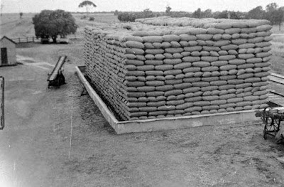
And still on the Carpolac line - A. Ampt has commented on the much discussed Museum Victoria pic of the wheat stack at Remlaw, or is it Natimuk?
Stack of wheat bags, 1930
He says it IS at Remlaw looking east, towards Horsham. And yes there is a peppercorn in the Remlaw siding yard too!

So another road trip out to Remlaw Station Rd to see if we can line up all the elements. A road that could be the Remlaw Station Rd (or Sission St) is visible entering from the right. And is the peppercorn tree hiding the Remlaw Rd to Horsham?

Okay after a drive by here is a present day photo of Remlaw Siding looking towards Horsham.
Remlaw, the shadow is cast by one of the silos
And the verdict - yes the Museum photo is Remlaw. Even though not taken from the same height, the weigh-bridge is visible on the left, the peppercorn to its right (though strangely it appears to be shorter now & impossible to park a vehicle under), then the tall sugar-gum now with a sparser canopy, then the plantation at the paddock corner. There is a shed at the group of trees on the right which may or may not be faintly visible just above the stack.

Saturday, 7 January 2017

Yonder to Yanac

Following a comment concerning the ‘Railways – Yanac line’ post in August 2016, which referred to an article featuring the history of the Jeparit - Yanac branch-line published in the Spring Edition of the ‘Australian Railway Enthusiast’ magazine, we have sourced a copy from the State Library of Victoria’s collection (Thanks SLV).
Titled ‘Yonder to Yanac-a-Yanac Jeparit – Yanac branch line history’ by Bruce Payne, it follows the establishment of the lines from Dimboola to Yaapeet and the branching from Jeparit through Detpa, Lorquon and Netherby to Yanac, and details how the line was constructed –
Detpa 255½ mile (441km) 318ft (97m) ASL
Detpa opened with the line to Lorquon and appears to have always been operated under no-one-in-charge conditions. The name is native “wait” or “stop a bit”. There was once a suggestion of naming it ‘Hindmarsh’ but this never eventuated. It consisted of a siding, sheep race, silo complex of 13,300 tonnes in 1984, 15-ton weighbridge, and a Mallee shed situated on the passenger platform.
Detpa in 2012
Lorquon 261½ mile (421km) 356ft (109m) ASL
Lorquon became the terminus and train staff & ticket station from December 1912 till the line was extended to Yanac in 1916...it consisted of 2 sidings, silo complex of 9,700 tonnes in 1984, 15-ton weighbridge and a platform with a small station building.
Lorquon's silos & weighbridge
Netherby 267½ mile (431km) 406ft (109m) ASL
Netherby was named after Netherby in Yorkshire and the ship Netherby wrecked off King Island. It was established as a train staff  and ticket station when the line opened to Yanac in June 1916. Initially it was operated by a Station Master who also supervised Yanac. He was replaced by a caretaker in September 1922, then dis-established as a staff and ticket station in December. The caretaker remained till May 1976. Netherby had 2 sidings, a sheep race, silos of 14,200 tonnes, a 2½ ton crane, 15 ton weighbridge and a small wooden station building.
The Netherby silo complex
Yanac 279½ mile (450km) 421ft (129m) ASL
Yanac opened on 27 June 1916 and operated under caretaker-in-charge conditions. The station facilities were two sidings, a cattle & sheep race, silos of 14,000 tonnes, a 2½ ton crane, 15 ton weighbridge, a small wooden station building, loco water storage and a crew rest house. A turntable never eventuated, and the station building was downsized and finally removed. It operated under caretaker conditions till July 1976 and officially closed on 8 December 1986.
Site of Yanac's station building, looking toward Netherby today
 
Bruce's view of Yanac in 1975 (sorry for the flaring)
Yanac's silos without the Goods Shed & Station building looking west to the buffers at the end of the line
Thanks to Bruce's article for all the information and the historic photos.


Thursday, 4 August 2016

To visit or not to visit

Spencer Street Passenger Yard, 1884 (SLV)
I was looking for something totally different, when I came across the "Victorian Railways tourist's guide : containing accurate and full particulars of the watering places, scenery, shooting, fishing, sporting, hotel accommodation, etc. in Victoria ; also a new and complete railway map showing all the present and projected lines" edited by Joseph Pickersgill, published by Sands & McDougal in 1885, and available online via Trove at http:/​/​nla.gov.au/​nla.obj-268214772


It describes the towns and cities in Victoria at the time, and really was not that complementary about this area, especially as it was a 'tourist guide'.


 ARMSTRONGS,
Which is not famous for anything in particular, and about six miles further on is
GREAT WESTERN.
This important place lies in undulating country on the Concongella Creek, a tributary of the Wimmera River, and to the north of the Black Range, and is the centre of a magnificent wine-producing district. Here, amongst other smaller ones, is the justly celebrated Great Western vineyard (Best's), famous for its extensive cellarage, and above all for the excellence of the wines of all kinds produced there, which have taken prizes at most of the World's great Exhibitions. A visit to this place will amply repay the tourist's time if only to
"Sit 'neath the shade of the spreading vine,
And drain a deep draught of Great Western wine,"
From Great Western to
STAWELL,
Also known familiarly as Pleasant Creek and the Reefs, is about 8 miles, being 19 miles from Ararat, 76 miles from Ballaraat, and 176 miles from Melbourne. Stawell is a large and somewhat straggling place, the streets in the old part of the town in particular being narrow and tortuous. In fact, the top end of Main Street (the Collins Street of Stawell) is as crooked as a dog's hind leg.

One wonders whether the author got a sample of some Best's sparkling, as he/she is a bit scathing of everywhere else, and it continues -

GLENORCHY,
Eight miles north-west of Stawell, and on the line of railway, is a pastoral township of the smaller type. The native name is Djarrah, which means a job of work. It is only noticeable as being the starting-place for
BALMORAL,
A place of about equal calibre. The only reason for mentioning these out-of-the-way townships is that the road between them passes through Rose's Gap, a gloomy, precipitous gorge in the Grampians, well deserving a visit, whose native name, Barregowa - meaning Middle of the Mountain - sufficiently indicates its character.
Quitting Glenorchy, the train passes the little townships of LUBECK and MURTOA, and proceeds to the comparatively large town of
HORSHAM,
The most important and the liveliest place in this part of the country. It is the centre of a flat agricultural and pastoral district, some of the finest grazing land in the country being in the neighborhood. The botanical gardens, as in the cases of Koroit and Stawell, were laid out by Mr R.P. Whitworth under the supervision of Mr W.R. Guilfoyle. Horsham has two newspapers, the 'Times' and the 'Wimmera Star'. The town possesses no special attraction, except to those who wish to see pastoral country, and it is questionable whether it is worth coming so far to see so little. It may be remarked that it was in this part of the colony that the late Marcus Clarke gained his colonial experience.
The pastoral centres of Dimboola and Tarraginnie lie still further afield, but whether to visit them or not is purely a matter of choice. 
Steam train passing through farm land c1890-1900 (SLV)
So what were the chances of getting a special excursion train to visit the Wimmera in the 1880s, based on this guide?

Wednesday, 15 June 2016

The big palette

Compliments to the Yarriambiack Shire who are chasing dollars for 'the world's biggest art gallery'.
On the back of the phenomenal success of the Brim Silo Art project  (see the previous 'High art' post) the Shire is proposing a 'Silo Art Trail' - a 200km trail of landscape size silo art from Rupanyup in the south to Patchewollock in the north.
Sheep Hills silos (which would have looked the part in 'The dressmaker' film)
Yarriambiack Mayor Cr Ray Kingston wants to commission renowned artists to paint giant murals on silos along the length of the municipality at Rup, Sheep Hills, Rosebery, Lascelles and Patche.
Guido, Adnate & Rone 'Wall to Wall' in Benalla
Discussions are taking place with the local communities, Graincorp, Juddy Roller (who helped bring Guido Van Helten to Brim), and government. They are targeting high profile street artists for the project, so it would be great to see, say an Adnate piece decorating a silo wall.
Silos at Rosebery, across the road from the Desert Gallery & Cafe
WDA's new director Ralph Kenyon said that the project would tie the long narrow municipality together (Yarriambiack is over 7,000 square kms, but over 160kms long and under 70kms at its widest).
Lascelles provides a variety of canvases
 As Dean Lawson stated it is a master stroke for increasing growth & development via tourism in Yarriambiack, as visitors will want to tick off each location as they bag each 'peak', in the biggest regional art project in Australia's history.
Adnate in the Geelong B Power Station
Would have liked to have seen the Nullan silos get a guernsey, they have a wonderful symmetry as they rise from the plain, particularly good at dawn.
Nullan siding silos, near Minyip


Tuesday, 24 May 2016

Vanishing Ashens

An addendum to the Railways - Melbourne to Adelaide line post, adding in the tiny siding of Hopefield (or Ashens).
The information comes from Vida Roberts, whose grandfather Henry W. Aumann selected 317 acres of Ashens Parish in 1872. He named the land ‘Hopefields’.
Ashens Parish showing the diagonal rail line passing through Allotment 220
When the railway pushed through the 10 mile section from Lubeck to Murtoa in 1878, it passed through Henry’s Allotment 220, and being the nearest landowner to the siding, the siding became Hopefield. By 1920 the siding took on the name of the Parish and had become Ashens.
Rail line from Ararat to Serviceton in 1890
The siding had a platform with a shelter shed of roofing iron with wooden benches, and a gatehouse occupied by a railway fettler and his family, who manned the railway gates at the Jackson Road intersection. The trains ran at least half-hourly in its heyday (except on Sundays), with 2 north-bound and 2 south-bound passenger trains daily. Potential passengers flagged down the train by waving a red flag stored in the Flag Box in the shelter shed. By 1900 the gates were replaced by ‘Railway Crossing’ signs, but the fettler remained.
The line in 1920 (the Riachella/Wal Wal Ballast branch line already closed)
The siding was changed to ‘Ashens’ after protests of mail and goods bound for Hopetoun were off-loaded at Hopefield.
Today the railway still passes by, but traces of the siding have vanished.
Satelite view of the Hopefield area

Friday, 5 February 2016

Motoring on the rails

This Post is in reply to Steve Henderson's Comment on Brimming with memories, concerning a photo of a railmotor at Brim. 
So here is the photograph from the book "Victorian railway railmotors : a photographic profile 1950's-1980's" edited by Neville W. Gee and John Sargent.
The railmotor 57 at the now demolished Brim station
 Possible identities in the photograph are - (man leaning on the post), woman with handbag, woman in check skirt, Station Master Don Newick (man in VR uniform), Ralph Crisp (man with case), man with cases.
The Diesel-Electric Rail Motors (D.E.R.M.) first entered service in 1928 and the last was withdrawn from service in 1991. They had a maximum speed of 100km per hour, and a maximum of 54 passengers.

Between 1928 and 1931 the Victorian Railways purchased 10 Petrol Electric Rail Motors produced by the Electro-Motive Corporation of the US. Known as the E.M.C. Model M-300, these units were supplied for assembly by VR at the Newport Railway Workshops and were converted to diesel-electric between 1951 and 1953. These units carried the numbers 55 to 64.
 
In the book, there were a couple of other railmotors in the region:
  

DERM 64 in Hopetoun, taken looking north , the station building & platform have since been removed. The Goods Shed on the left is still on site.


DERM 57 was modified to diesel in December 1952. Retired in March 1982. Sold for scrap in November 1982.

DERM 63 was restored to 1930s livery and is now on the Daylesford Spa Country Railway.  

DERM 64 is apparently being restored.

(Below) DERM 63 at the dock platform in Murtoa, with the now demolished Signal Box behind, looking south.

Sunday, 10 January 2016

High art

With headlines “Tiny Wimmera town brimful of pride” and “Giant silo art dubbed tiny Wimmera town’s Mt Rushmore” the media and online response to the Brim Silo Art has been amazing.
The silo’s mural has its own Facebook Page
The finished mural against a Wimmera sky. Donna Wallace Facebook
Internationally renowned Brisbane-based artist Guido van Helten is using regional Victoria’s largest cherry-picker to breathe new life into Brim’s disused grain silos with a 30m by 30m artwork. For 3 weeks he has worked for up to 10 hours a day, including Christmas Day and New Year's Day, in frequent 40-degree heat and strong winds to create the work using spray paint and acrylic house paint.

Guido on site, by Rob Leeson
 “I work on photography so when I got here I arranged a small photography project, which sort of documented the people of the town,” Guido said, and he had wanted to paint an iconic Australian silo for years.
The rough, round surface of the silos and a scorching, wind-battered central Victorian summer meant the task had not been easy.  Van Helten took photos of locals and mapped the work on computer, but a challenge was to accommodate the silos' curves.
A blank canvas, by Paul Carracher
Funding from Regional Arts Victoria, the Yarriambiack Shire Council, Brim Active Community Group and a paint sponsorship by Taubmans and Loop Paints allowed work to get under way before Christmas.  The local caravan park and pub provided free accommodation and meals.
Guido in action with the spray gun he also used a paint brush, by Rob Leeson
Brim Active Community Group president Shane Wardle said the artwork was already making a difference to the local community.
“The Facebook has been unbelievable. It’s even gone overseas now. One lady said the next time she comes to Australia she’ll be coming to Brim to have a look at the silo. It’s just amazing.”
Any boost for Brim’s people and their businesses would be a bonus, “If the pub sells another beer and the shop sells an ice cream, we’re happy with that,” Shane said.
Guido on the boom dwarfed by the silo, Rob Leeson
Now 4 giant figures representing generations of the area’s people will loom over the Henty Highway in a sight sure to join Australia’s big things as a road-trip must.
The now vanished image, Paul Carracher
Visitors are driving for hours to see the  giant mural overlooking the tiny community of Brim. One visitor compared it to Mount Rushmore, the giant sculpture of four US presidents in South Dakota.
Originally the second character was a child's face, till Guido thought it didn't fit with his vision, so after all that work he changed it to what we see today. Fortunately the Mail Times captured the work in progress.
Brim Silo Art is now a masterpiece of outdoor art using the canvass of unused grain silos. But Brim is not alone with many small towns left with now unused silos, tall, blank, grave monuments to an once important part of a small towns economy.
The cement silos at Brim were built back in the 1938 and were never designed to last this long and are still in working order, but due to the larger carrying capacity of trucks, they were decommissioned approx 3 years ago, and now all grain now is either stored on farm or is sent to the Beulah or Warracknabeal bunker storages.
Grain silos are being shut down because of cost cutting rationalisation by grain purchasing companies. The cost is being shifted from the corporations to the family farmer who has to bear the cost for shifting grain the extra distance from the once local silos to a bigger centre. 
Guidio van Helten is a well-known & recognised muralist, check out some of Guido's other great work via his webpage,  some of them in much colder climates.
: Lynton Brown's drive-by video
: 7News video
: ABC Rural's article on the people on the silo
: Brim Silo Art Project
Peter, Sam, Win, Al & Guido. Mikala Hateley on Facebook

Sources: The Age, Herald-Sun, Mail-Times, Facebook

Wednesday, 24 June 2015

Patching Patche

Great news this week that VicTrack's Heritage Program will be funding the repair of Patchewollock and Kaniva railway station buildings.
Patchewollock - end of the line
The very dilapidated Patchewollock station building will be re-clad, the roof and walls repaired and painted and new guttering and downpipes installed. The Goods Shed will be restored by re-stumping, painting, new guttering and downpipes and structural repairs.
Kaniva's Goods Shed from the station platform
The work on Kaniva's station building and goods shed will commence shortly.
Donald-based heritage restoration firm Onley's Holdings will undertake the task. 

Below: The Patche line still open in 1966, taken from Nick Anchen's 'The right way, the wrong way & the railway : great Victorian railway stories'. It includes a story of crews battling through sand drifts to reach the remote Patchewollock terminus, passing families along the line, who would stop the train in the middle of nowhere, by waving a lantern, to receive their provisions.