This blog provides information, stories, links and events relating to and promoting the history of the Wimmera district.
Any additional information, via Comments, is welcomed.


Showing posts with label Bridges. Show all posts

Wednesday, 12 October 2016

Tarrying at Tarranyurk

Prompted to share a couple of bridges in flood.
The previous photos of the old Tarranyurk Bridge on the "Bridges in floods" post were taken in March 2008 and April 2011.
The Wimmera River swirling into the Old Tarranyurk Bridge (Dimboola Courier)
These are from the Dimboola Courier and were taken on Tuesday 20th September 2016, as the flood peak moves towards Jeparit.
Hang in there Tarranyurk! 

The partially collapsed deck of the bridge, the current bridge is to the left (Dimboola Courier)


Began this post on 22nd September, but now updated, so it was possible to add a few more flooded old bridges taken on 24th.

Firstly - Antwerp, the flood peak had moved on from around Antwerp, but evidence of the higher level was apparent with debris still piled up against the old bridge deck, which as shown is only just above the water level. 

<< The new & old Antwerp bridges

Below the old bridge with its missing span, from the previous flood in 2011.


Both Tarranyurk bridges


Arriving at Tarranyurk, the flow of the river was evident, with little whirlpools and frothy spume whipped up around the piles.

  The bridge deck at Tarranyurk  >>


Moving on to Jeparit - the peak had again been and gone, onto Lake Hindmarsh. 
The waters had only reached part-way up the cross-members of the trestles.
Above & below - Jeparit

Thursday, 22 September 2016

Tarrying at Tarranyurk

Prompted to share a couple of bridges in flood. 
The previous photos of the old Tarranyurk Bridge on the "Bridges in floods" post were taken in March 2008 and April 2011.
The Wimmera River swirling into the Old Tarranyurk Bridge (Dimboola Courier)
These photos are from the Dimboola Courier and were taken on Tuesday 20th September 2016, as the flood peak moves towards Jeparit.
Hang in there Tarranyurk! 
The partially collapsed deck of the bridge, the current bridge is to the left (Dimboola Courier)

Monday, 22 August 2016

The flow of time

As the rains come tumbling down, people's thoughts turn to the river.
This piece is from the Dimboola Courier: 

The first natural flow in the Wimmera River since 2012 flowed past Antwerp earlier this week and had progressed northwards to a point beyond the Tarranyurk bridge by Friday evening 12th August.

Wimmera Catchment Management Authority said the natural flow peaked at 468 megalitres a day at Lochiel.
Prior to this event the river had dried up to the point where it was just a series of stagnant waterholes linked by stretches of dry riverbed with only the weir pools at Dimboola and Jeparit holding any significant quantities of water in the lower reaches of the river.

The old Antwerp Weir in April 2016 (Dimboola Courier)
The weir, August 2016 (Dimboola Courier)
The only man made structure on the river between the Antwerp and Tarranyurk road bridges is the old Antwerp weir (pictured above) which was constructed of timber and stone in 1903 to create a more permanent body of water for the local community. The weir pool became the venue for the annual Antwerp rowing regattas in the following years.
It is unclear when it was no longer required and fell into disrepair, but a significant amount of the structure still remains.

Proposals were put forward in the early years of last century to construct a similar structure near Tarranyurk to provide a water supply for that area but this never built.

This series of photographs were taken in the vicinity of the Antwerp weir both this week and back in April and they highlight this structure in the dry and with the water flowing. 

The weir in 1903 (SLV)
The historical photograph, taken in 1903, compares with the one below, taken recently from a similar location to show the changes over the last century. The most obvious being the regrowth of trees around the weir itself.
The Antwerp weir in August 2016 (Dimboola Courier)
The water arrived at Jeparit a day later, and will now flow into Lake Hindmarsh. The last inflow into the lake was as a result of the 2011 floods.
The Jeparit Weir, August 2016 (Dimboola Courier)
The last time that the lake itself flooded was in August 1956. At Jeparit, the Wimmera River rose and forced Lake Hindmarsh to burst its bank near Four Mile, when the inflow overwhelmed the ability of Outlet Creek to cope with the huge volume, and was further  compounded by the wind and waves forcing the water towards the south. Hundreds of acres of wheat crops were affected, several roads were cut, two families were forced from their homes and 30 others were threatened.
The old Jeparit road bridge in 1956, from the north bank (L. Hounsel)
The historic photograph shows the water up to the corbels of the old road bridge over the Wimmera River.The photo below shows the struts and pilings visible below the corbels.
The old Jeparit road bridge in November 2007, from the south bank

Saturday, 21 December 2013

Horsham Bridges

Two lanes of traffic negotiate the west bridge during the bridge works
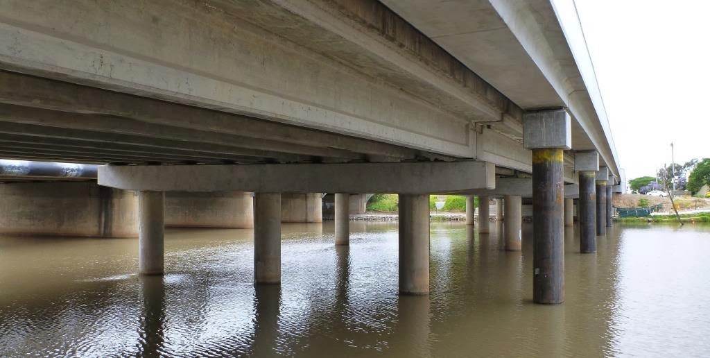
Work on the extensions to the Wimmera River bridges in Horsham are continuing, and as traffic is diverted for the third time, it is now possible to see the evidence of the work done to increase the breath of the bridges.
The bridge from Sawyer Park, 2012

The Wimmera River rises in the Pyrenees region and generally winds westward, passing through Horsham, ending up at its termination at Lake Hindmarsh. 
In Horsham, bridges over the Wimmera River now divide the southern section of the city from the central and northern portions. The bridges provide a vital link connecting the northern and southern suburbs of Horsham and carry as many as 23,000 cars and trucks each day.

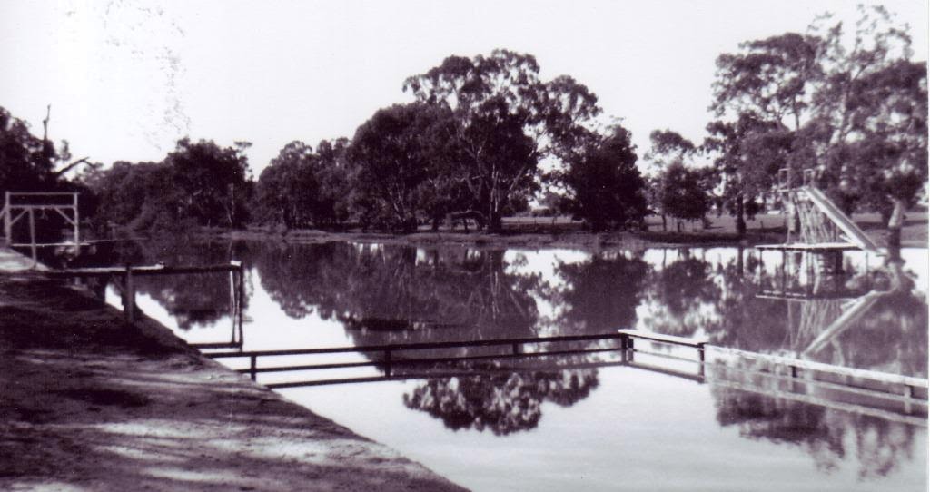
The swimming hole c1938 (Horsham & District Historical Society)
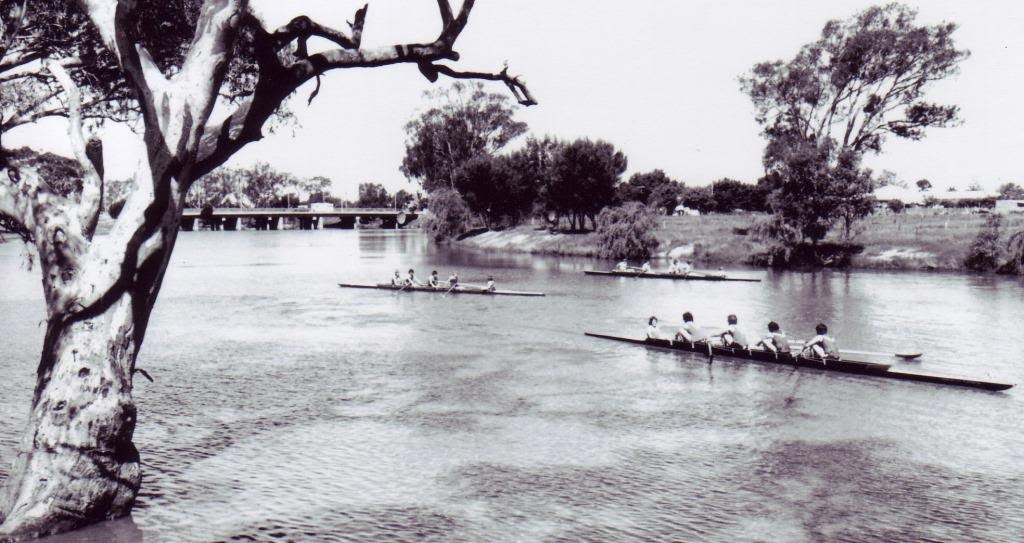
The first timbered weir site was near the Botanic Gardens and formed part of the swimming hole. During the 1960s drought, a new weir was built in 1968, further west at the end of Drummond Street, and the river cleared between the weir and the bridge. In the late 1800s and early 1900s Chinese market gardeners grew their vegetables on blocks near the river. The first rowing clubs began in the 1880s and continue today.
Rowers with the bridge in the background (Horsham & District Historical Society)
The river has flooded semi-regularly, in the big 1909 flood, the water reached Pynsent & McLachlan Streets, and May Park. Other major floods were recorded in 1915, 1950s, 1964 and 2010.
The original timber bridge was built in 1884 by James McClounan. In 1892 the Council were required to replace its brittle timber deck with sturdier red-gum planks, these were still limited to 4-5 tons.
The timber bridge from Green Park (Horsham & District Historical Society)
This bridge was replaced in 1939 by a single lane concrete bridge. In 1976 a second bridge (the westward) was constructed longside, and the first bridge remodelled to match it. The gap between the two was the site of the timber bridge, which was demolished during World War II.
The two bridges in 1978 (Horsham & District Historical Society)
Construction works (WMT)

The $4.26 million bridge upgrade is being jointly funded by the Australian and Victorian governments as part of the larger Western Highway upgrade.

Works will include widening the footpath to improve pedestrian and bicycle access, widening road shoulders, installing bridge safety barriers between pedestrians and motorists and constructing strengthening works - a thicker concrete decking, and widening  the existing traffic lanes on both bridges.
The new circular piers for the pedestrian footpath
 The bridge project works are planned to finish in April 2014.


Monday, 2 September 2013

Balmoral line again

I'm re-posting the Balmoral line, as I've come across some more information and taken some recent photos. This post does not replace the original one from November 2012, I've just swapped some photographs, added new ones of current views to compare against the old, and finally I'm including Natimuk itself (really on the Carpolac line) in reply to a Comment I had on Remlaw (see below).
The Balmoral line was a north-south running cross-country line that connected Hamilton, and ultimately Portland, with Horsham, via the junction at East Natimuk. The line from East Natimuk to Noradjuha officially (and finally) closed in 1986, with the Horsham to East Natimuk closing in October 1988. Noradjuha to Hamilton had been closed since July 1979.
Leaving Horsham the line to Natimuk passes Remlaw. I had an historic photo from Museum Victoria purporting to be a wheat bag stack at Remlaw in 1930.
Museum Victoria photograph
I've since had a Comment posted saying they believe the location is in fact Natimuk, not Remlaw, so I felt compelled to investigate, and now I too conclude that it is at Natimuk, facing west towards Carpolac.
Natimuk today - with the same peppercorn tree & gum tree on the horizon
Checking at Remlaw, the trees in that locality don't match, so well done that eagle-eyed follower, and thanks for your comment (I've contacted the Museum too).
Rows of sugar gums in front of the Remlaw silos
Before reaching Natimuk East, the line had to negotiate a crossing of the Wimmera River at Quantong (though the road bridge was called the Vectis Bridge in the early days). Below is a great photo by Bob Wilson of one of the last trains to cross the bridge in 1983. The timber trestle bridge was built in 1887, and is 133m long.
The road & rail bridges at Quantong (from 'Power to the rails' by John Scott)
Natimuk East was the former junction station, splitting the westward Carpolac line and the Hamilton cross-country branch line heading south via Balmoral. Not much trace of the platform remains, it is still an important grain receival point with large bunker storages. 
At Natimuk East, the Carpolac line ran in a curve from the left then down the centre of the photo, while the Balmoral line enters from the right, its platform mound is between the two groups of trees then it runs parallel to the Carpolac one past the silo, where they join and veer right towards Horsham at about the shadowed area.
The Natimuk East silo shed with the bunkers behind
From Natimuk East the line passed through Noradjuha to Jallumba. Jallumba opened in September 1912 and closed in 1979.
Jallumba, the platform mound is on the left
The Jallumba Goods Shed 1989 (from When There were Stations)

Site of the Jallumba Goods Shed today - no trace
From Jallumba the line continued south passing Carchap. Though not a listed siding, Carchap boasted a school and pumping station as it was on the water channel from the Toolondo Reservoir (built 1952-53).
The Carchap bridge the school was on the right
This bridge is the only one I've found still existing (apart from the Fulham trestle) on the Balmoral line all the other bridges and culverts have been removed. From Carchap it was only a few miles to Toolondo.
The abandoned Toolondo yard, not even the Super works operate from there any more
With the rails removed at Jeffries it is now difficult to plot the line's course.
Jeffries in 1980 (VRS photo)
The overgrown track at Jeffries today
Further south was Kanagulk, due to wartime shortages the line did not extend to Kanagulk until the end of 1917, and strangely the Kanagulk station looks better today than it did back in 1980.
Kanagulk in 1980 (from Winkieg on Flickr)
Kanagulk today

Wednesday, 27 July 2011

Bridges in floods

With news reports on the Dimboola Weir this week, it harks back to the "Still going strong" post in January, when I mentioned a number of wooden bridges. Since then the flood waters have come and gone, and now the roads are open again, We've had our first chance to see the bridges on the lower reaches of the Wimmera River.

Firstly at Jeparit - as seen in the photograph above (2008) and below (2011) not much has changed, despite the township of Jeparit being surrounded by floodwater and the sandbags still on the levee bank. Maybe the corbels on the extreme left have fallen away more, but really it looks remarkably similar.

The Jeparit Bridge was built in 1892 with hewn timber corbels supported by big timber struts. It has seven main trestle and girder spans using strut & crown girder construction.


It was evident from this approach shot ^ of the Tarranyurk Bridge that this one had suffered more than the Jeparit one. It looks as if a chunk has been removed from the upstream side of the roadway. This is a bypassed road bridge west of Tarranyurk on the Tullyvea Road.

Two views of the Tarranyurk Bridge, taken from on the new bridge. In the 2008 photograph, the bowing and buckling of the deck can be seen, and now with the missing trestle the bending is more pronounced.


From under the deck, you can see the reason why the bridge fell in.

The March 2008 photograph shows that the right-hand support had already rotted through and was misaligned, and the one next to it was also extremely worn at the straight beam level.

The 2011 photo was taken from a different spot due to the higher water level and is a span further away. You can see the light coming through from the missing deck area.


At Antwerp the bypassed timber road-bridge on the Antwerp-Woorak Road, was already missing a roadway span, as evident in the 2008 picture.

This probably helped lead to the partial collapse of that section as the trestles have given way and now lean into the river, and the roadway bitumen has separated and dropped several feet from where it met the approach ramp.


A large amount of debris was piled up against the supports on both the new bridge on the upstream side, and the old bridge. The tree trunks still lodged in the old bridge attest to that, and to the height of the river level at the time.