This blog provides information, stories, links and events relating to and promoting the history of the Wimmera district.
Any additional information, via Comments, is welcomed.


Tuesday, 24 December 2013

Eucalytpus Christmas

Merry Christmas

from Way Back When

Saturday, 21 December 2013

Horsham Bridges

Two lanes of traffic negotiate the west bridge during the bridge works
Work on the extensions to the Wimmera River bridges in Horsham are continuing, and as traffic is diverted for the third time, it is now possible to see the evidence of the work done to increase the breath of the bridges.
The bridge from Sawyer Park, 2012

The Wimmera River rises in the Pyrenees region and generally winds westward, passing through Horsham, ending up at its termination at Lake Hindmarsh. 
In Horsham, bridges over the Wimmera River now divide the southern section of the city from the central and northern portions. The bridges provide a vital link connecting the northern and southern suburbs of Horsham and carry as many as 23,000 cars and trucks each day.

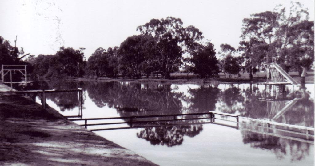
The swimming hole c1938 (Horsham & District Historical Society)
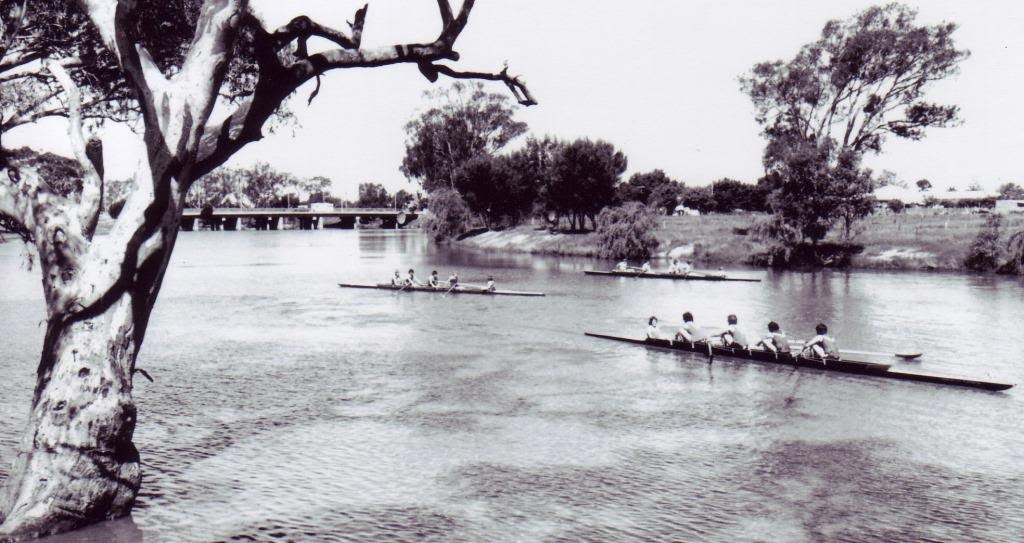
The first timbered weir site was near the Botanic Gardens and formed part of the swimming hole. During the 1960s drought, a new weir was built in 1968, further west at the end of Drummond Street, and the river cleared between the weir and the bridge. In the late 1800s and early 1900s Chinese market gardeners grew their vegetables on blocks near the river. The first rowing clubs began in the 1880s and continue today.
Rowers with the bridge in the background (Horsham & District Historical Society)
The river has flooded semi-regularly, in the big 1909 flood, the water reached Pynsent & McLachlan Streets, and May Park. Other major floods were recorded in 1915, 1950s, 1964 and 2010.
The original timber bridge was built in 1884 by James McClounan. In 1892 the Council were required to replace its brittle timber deck with sturdier red-gum planks, these were still limited to 4-5 tons.
The timber bridge from Green Park (Horsham & District Historical Society)
This bridge was replaced in 1939 by a single lane concrete bridge. In 1976 a second bridge (the westward) was constructed longside, and the first bridge remodelled to match it. The gap between the two was the site of the timber bridge, which was demolished during World War II.
The two bridges in 1978 (Horsham & District Historical Society)
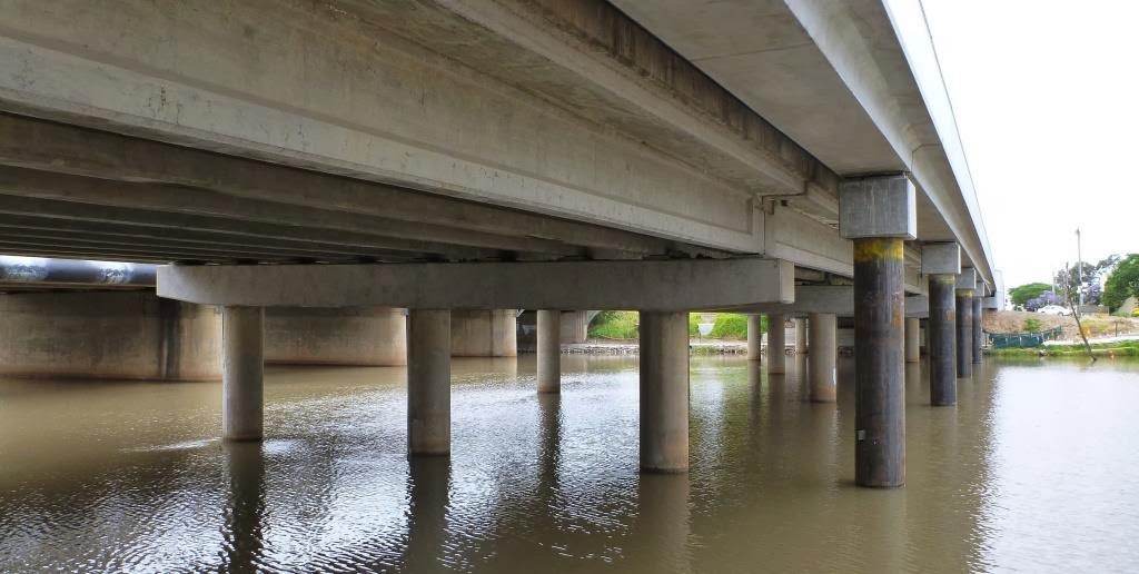
Construction works (WMT)

The $4.26 million bridge upgrade is being jointly funded by the Australian and Victorian governments as part of the larger Western Highway upgrade.

Works will include widening the footpath to improve pedestrian and bicycle access, widening road shoulders, installing bridge safety barriers between pedestrians and motorists and constructing strengthening works - a thicker concrete decking, and widening  the existing traffic lanes on both bridges.
The new circular piers for the pedestrian footpath
 The bridge project works are planned to finish in April 2014.


Friday, 13 December 2013

Styling stations


This post grew from this comment -
"Can someone please elaborate on 'Bealiba style'? I was brought up in Bealiba and spent years hanging around the Bealiba Station but have never heard of the term. Thanks Brian H." on the earlier post ‘Railways - Mildura line’ and led to a little research at the State Library.

The 1870s was an era of railway building, that ended with the financial crash of the early 1890s, when railway lines were extended westward. During this period, the development of a succession of standard plans coincided with the patterns of railway construction, establishing groups of stations common to sections of line.
Bealiba in 1980 (Andrew Ward)

There developed a "line style", in which similarly-designed station buildings imparted their distinctive character along a particular line. The Bealiba station building was one in the “light line” style along one of the “main trunk” lines and gave its name to a prototype style which was an economic solution to the previously costly construction of railway station buildings.

According to Andrew Ward in a ‘Study of Historic Railway Buildings and Structures’ and 'Victoria's Railway Stations: An Architectural Survey', the Bealiba Style is an earlier sub-group of the Rosedale Style. He says the Rosedale style developed in response to the need to save on construction costs,and was the first design to be widely employed for all-timber type buildings. In all, 12 Rosedale style buildings were erected (Cope Cope was the only example in this district) and 6 in the earlier Bealiba Style of station building - Bealiba, Broadmeadows, Euroa, Kilmore East, Lubeck, Murtoa and Wallan.
Lubeck in 1981 (from VRnet)
Constructed in 1878, the Bealiba building is still substantially intact as an example of the style. Elements of the Bealiba Style are: An oblong single-storey plan timber construction with bisecting longitudinal corridor which terminated at a porch. The combined station and residence had a verandah to the platform formed by an extension from the main roof. Four rooms were residential (2 bedrooms, parlour& kitchen) and 2 for railway purposes – the Booking Office and the Ladies Waiting Room. The 4 corner rooms all had fireplaces. The lamp room & toilets were all in the station yard. Copying the diminutive Dooen Style, the barge boards were fringed with cast-iron lace-work, and ornamental brackets adorned the porches. The verandah post capitals, gable vents and finials all had decorative timber work. The interior walls & ceilings, and lamp room & toilets were lined with tongue & groove boards.
Plan of the Bealiba building (Andrew Ward)

The later Rosedale style omitted the cast-iron lace-work, the end porches and 2 fireplaces, but now included a General Waiting Room.

Other stations in the area awarded a “style” are:

·     The "St. Arnaud style" (1879) comprised an architectural symmetrical single-storey hip roofed brick station with cast-iron platform verandah and pavilions and a standard U shaped plan for the station building. It is the most intact example of the largest standard station building design erected on the early light lines.

St Arnaud's water tower

Also the St Arnaud water tower was built as a standard 'Type B2' hemispherical design carried by a 'T' iron frame and installed onto a cement rendered brick column. It is the last remaining example of this construction, with other B2 type towers originally located at Cranbourne, Bealiba and some metropolitan locations.

Diapur station building in 1971 (from "VR stations & stopping places")

·     The “Kaniva Style” which in addition to Kaniva itself, included Diapur, Leeor (to Melton), Miram and Nhill. Small timber buildings with classical decoration & gables.

The ornate platform verandah, Minyip

·     The “Minyip Style” used for Minyip and Yarra Junction.

·     The “Rupanyup Style” used at Rupanyup and Bairnsdale

Past glories - the dilapidated Rupanyup building

A “Special Design” was used for Serviceton, Warracknabeal (1887) was built in the “Casterton Style” a Tudor/Late Victorian look, while Dimboola (1882) is in the “South Melbourne Style” the Italianate/Late Victorian style.

The same style - Donald & Birchip


Tuesday, 3 December 2013

End of Ebenezer Era

The National Trust of Victoria are relinquishing their role in the Ebenezer Mission Station and handing the freehold of the property to the Barengi Gadjin Land Council.
The Aboriginal Mission Station officially commenced on 2nd May 1859 when Moravian missionaries arrived at Horatio Ellerman's Antwerp property. In 1861 a Crown Grant was issued for the 1,890 acres, situated on a bend of the Wimmera River 2 miles southwest of the Antwerp township, to use the land for the promotion of the welfare of the aborigines. Rations were supplied to the residents by the government on the condition they attended church services and school, and in exchange for work.
The first school for Aborigines was opened in 1859 by the Moravians who operated the Mission, but when the mission discontinued, the school closed in December 1903.
Ebenezer is the oldest surviving mission church and buildings in Victoria.
As part of the changeover there will be a function at Ebenezer next Thursday 5th December beginning at noon with a lunch, smoking ceremony and guided tours of the site.

Tuesday, 26 November 2013

Upper Regions

Out in the country looking for school sites, I came across the 'Upper Regions Cemetery'.
The Cemetery Reserve site was gazetted in November 1877.
It's first Trustees were appointed in August 1881, and you can see the German Lutheran heritage of the area reflected in the names - Peter Koop, August  Petschel, John Menzel, Gustav Stephen and August Janetski.

 They obviously had grand plans for a huge population boost back then, which wasn't realised, as the plots are concentrated in a back corner.
Despite its overgrown state, you can make out the grand central corridor of pines dividing the site into the northern half which houses the occupied graves, and the southern half bordering Petschels Road.

The cemetery's Rules and Regulations of 1882 includes some gems -
Cemetery fees in 1882
  • A drawing of every stone, tomb, pedestal, and a plan of every monument or tablet proposed to be erected, and a copy of every epitaph or inscription to be submitted to the trustees for approval, who may withhold permission and prevent the erection of any monument which shall appear to them inappropriate or unbecoming, and shall determine and fix the position of any monument which may be preferred  to be erected according to the description, size, and character thereof, having reference to the general plan for ornamenting the said cemetery in an appropriate manner. 
  • No grave to be of less depth than 6 feet, except in the case of still-born children 3 feet. 
  • Family vaults to be limited to 10 feet frontage by a depth of 8 or 16 feet.
Time stands still
In March 1845 William Patterson took up the license for the Upper Regions station by the right bank of the Wimmera River, adjoining Dimboola. The name referred to its location in the up-country district, part of Dimboola developed on the station site. The station was subdivided in December 1856 into Upper Regions and Lochiel, Upper regions was further subdivided in April 1858 into Upper regions and Bonegar. The Upper Regions license was cancelled in November 1884, and Lochiel cancelled in September 1881.  

Sunday, 17 November 2013

Like a Rock


This November sees the celebration of 50 years of climbing at Mount Arapiles.

The Horsham Library is fortunate to have Keith Lockwood - who's family first settled in the Natimuk Lake area in 1871, and who has roamed the Mount since he was a boy - deliver a talk on the history of the mountain before its 'discovery' as a rock-climbing Mecca, and as one of Australia's best known cliffs.

Keith is the author of the book 'Arapiles : a million mountains'. This popular book details Arapiles from its ancient geological origins, its role in traditional Aboriginal life and culture, its discovery by Major Thomas Mitchell's Australia Felix Expedition and settler history, its flora & fauna and inspirational images in paint and film, and finally as the pinnacle of rock-climbing in Victoria...Australia...the World.

The program begins at 7:30pm on Wednesday 20th November at the Horsham Library. Bookings are essential, Phone 5382 5707 or visit the Library in the Mibus Centre.

Friday, 8 November 2013

They wrote what?

The Public Record Office of Victoria is conducting a number of free tours and information sessions (see their events calendar).
A list of signatures
Of particular interest is the "Reading 19th century handwriting" session. It can be particularly difficult to decipher the elaborate handwriting of times past, especially if you are only viewing a copy and not the original document.
 Are you baffled by the handwriting on 19th century documents? Is that a J or an F? An S or a D?
Stop tearing your hair out in frustration - PROV are here to help.
Come along to their information session on Thursday 21st November and they will show you how to interpret the handwriting of our forebears.
The "Reading 19th century handwriting" session commences at 1:00pm and finishes at 2:30pm. the session is free, but bookings are essential (follow the links from the events calendar to register). 
A selection of different handwriting styles

And why not make a day of it and attend the "Tour of the archives" in the morning (11:00am to 12 noon). A guided tour that ventures beyond the Get Smart security doors, through the air locks and into the purpose-built Repository - a collection of 180 years of our history in 90 kilometres of records (bookings are necessary for this free walking tour).
There are a number of other information sessions run by PROV, so check out the calendar.
The Victorian Public Records Office is located at 99 Shield Street in North Melbourne (off-street parking is via Macaulay Rd).

Monday, 28 October 2013

Ghostly murder

A new local non-fiction book has just hit the stands, and is being snapped up (over 300 copies were sold in the first month).
The book is ‘The true story of the Maryvale Murders and the Langley family ghost’ written by Rupanyup’s John Henry Ellen.
John was approached by Langley descendant Neil Langley to write the history of his aunt Maria Langley and her daughter Louisa Jane Sugers, who were murdered near the Sheepwash Reserve on what was then Maryvale Station in 1874.
The remains were not found till 10 years later in 1884, and prompted a nation-wide hunt for the murderer, supposed to be Maria's husband Robert Cook.
In the meantime the remains were housed in the stables of the Edenhope police station, here they languished until their presence was raised in the Victorian Parliament in 1917.
The political pressure saw the skeletons conveyed to the cemetery and buried in an unmarked grave.
Now years on the full story from the Langley family's point of view is recorded, including the story that maybe Maria's ghost has appeared to wayfarers.
The story employed family papers, newspaper articles, and provides a historic perspective to describe the times and the environment of the story.

Monday, 21 October 2013

A Trove of papers

The National Library in Canberra have digitised a number of Wimmera newspaper editions from the First World War era.
The Sanctuary in the Shrine of Remembrance
This digitisation is part of the efforts to commemorate the Anzac centenary. The newspapers include -
  • Birchip Advertiser & Watchem Sentinel
  • Donald Times
  • Hopetoun Courier & Mallee Pioneer
  • Nhill Free Press
  • Rainbow Argus
  • Rupanyup Spectator & Lubeck, Banyena, Rich Avon & Lallat Advertiser
  • Stawell News & Pleasant Creek Chronicle
  • West Wimmera Mail & Natimuk Advertiser
The newspapers can be accessed online at the Historic Australian Newspapers page of Trove.
Trove is the National Library's free federated online search service. It focuses on providing access to its national repository of all types of Australian material.

The Library will be conducting a free introductory session for people interested in learning more about Trove and the digitised newspapers, at the Horsham Library @ 2pm on Friday 25th October. 
Bookings are essential and can be done by calling in at the library or by phoning 5382 5707.