This blog provides information, stories, links and events relating to and promoting the history of the Wimmera district.
Any additional information, via Comments, is welcomed.


Wednesday 30 January 2013

Railways - Mildura line 2

I'm re-posting the Mildura line, as I've added some more information and photos of stops. This one does not replace the original post from November, but I've swapped some photos added new ones of current views.

Mildura/Yelta (Ballarat to Ouyen) Line The line was opened between Ballarat and Maryborough by 1875, and extended to St Arnaud in December 1878, Donald in February 1882, and Ouyen by 1903. 
Emu station in 1971 (from "VR stations & stopping places")
Local stations - Emu was named after the nearby Emu Creek, it is still an important crossing loop, and the basic facilities replaced a station in the same style as that of Bealiba and Cope Cope. 
Emu today
Carapooee a lone peppercorn tree marks the site of the station.

The railway reached St Arnaud in December 1878, while the station was built  in 1879, the building was reflecting the gold mining heritage. Made of brick with cast iron verandah supports, the station master’s residence was incorporated into the design. No passenger trains have called here since 1993, the yard still sees use for freight. It is on the register of heritage buildings, as well as the unusual  hemispherical water tower, the last of this design remaining.
The St Arnaud turntable with the water tank behind & station building behind that
Sutherland the silos are all that remain of Sutherland which also boasted a school and church. 
Trees stand behind the Sutherland platform mound
Swanwater

Swanwater silos
Cope Cope  opened in January 1882, when the line was extended from St Arnaud to Donald in April 1882. A large wooden station containing offices, and a station master’s residence was erected on the site of the original state school, railway engineers moved the building aside to lay the rails. The station and goods buildings were demolished some time after 1986. Now only a raised mound of earth marks the spot.
Talking with an ex-railwayman, he believes there was also a siding named Laen, south of Donald.
The line reached Donald in February1882, during the summer drought of 1881-82, so the railway was needed to cart water to the town (nearly 2 million gallons of water were delivered to the town before the drought broke). The line opened for passengers and mail in April 1882.
Chute of the Cope Cope silo looking across the platform mound to a railway house
Donald Freezing Company Siding this complex deserves its own post. On the outskirts of the Donald township, straddling its own track, are the rusting remains of the Donald Inland Freezing Company's buildings. Covering 10 acres most of the buildings are abandoned or converted to other uses. The freezing section was turned into a yabby (freshwater crayfish) production plant 'Oz Crays' during the 1980s (now derelict), and the north-most section is home to 'Kooka's Country Cookies' (established in 1990s). Only the portion of the rail-line to the grain silos is utilised.
Freezer works on the left of the line, and the slaughterhouse on the right
Donald was the line’s terminus, until 1893 when the tracks pushed northwards. A 50' turntable was constructed. In 1914 the 4 locomotive engine shed was destroyed by fire, volunteers manually pulled a large DD engine from the shed while the other 3 could not be reached. A million bushel silo was erected in 1963. Passenger services ceased in 1993, and the Queen Anne style brick station building and passenger platform are no longer in use, but the station remains an active freight centre with a sizable yard and the large corrugated iron goods shed. 
Donald station building, with the silos looming behind
Donald was a changeover point for drivers and a large crew of railway workers were based in the town, a large contingent lived in Donald, and it saw the construction of a Railways Institute in 1963, across from the station yard. The building and grounds are now derelict since the rationalisations of the 1970s and 80s saw most of the job positions disappear.
The V.R. institute & bowling green
Donald marks the southern boundary of the 'Mallee', and as the line proceeded northwards it traversed wide plains of marginal farming land. During droughts week-long dust storms caused sand drift to accumulate on the tracks, derailling some trains.
Buloke is only mentioned on some maps. The siding was on a crossing of the Sunraysia Highway near the southern shore of Lake Buloke.

Litchfield was a wooden portable building and platform at the wheat siding. By January 1990 the platform had been removed, now only the silos and a small goods platform remain.
The decaying platform at Litchfield
From the level-crossing at Massey
Massey
Watchem was opened in 1893 (it was goods only in 1892), when the line reached Birchip. A grain shed was erected in 1894, the concrete silos were built in 1939, with the steel bins added later. The Oat Growers Shed was erected in 1959. Bunkers were created in 1982. The stockyards were demolished in the late 1960s. The long demountable station building had an extra roof attached to the present roof, to form greater protection, and a verandah for passengers, prior to 1912. Passenger services ended in May 1990. The building was removed to High Street during 1991 to become a residence, only the long wide platform now remains.

Morton Plains was established in 1893 when the line was extending from Donald to Birchip. Passenger traffic peaked in 1923/4 then declined to the point it ceased in October 1966. Stock yards were erected in 1900. The silo opened in 1941.
Morton Plains, looking remarkably like a reverse of the Massey photo
A Bulldog goods train at Birchip in the late 1910s (V.R.S. photo)
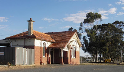
Birchip was the line's terminus from March 1893 until September 1899, when the track extended to Woomelang. The  Queen Anne station building with terracotta roof is used by the local electrician, and the nearby silos for grain.
Birchip station, the same design as at Donald
Karyrie (station no. 204) alternate suggested names were 'Woodlands' and 'Towma', but Railway Commissioners stuck with local homestead 'Karyrie'. It boasted a gangers residence until 1953 when the passenger service ended. Stock facilities existed from 1907 till 1953. Wheat was only stacked at Karyrie in bags. The station closed in January 1954.

The line reached Kinnabulla (station no. 205) in 1899 and passengers, stock and grain used the station until 1973 when the buildings, platform and facilities were removed or demolished, and Kinnabulla remained solely for grain transportation. Talking with the daughter of one of the Kinnabulla gangers last week, she reminisced about her time when there were 3 ganger family houses and a stationmaster.
Sheepyards at Kinnabulla with the fences made from railway sleepers
Curyo, Curyo is the Aboriginal word for a kind of small kangaroo. It was the name chosen for Hugh Mann and James Falconer’s pastoral station north of Birchip, which was taken up in 1847. The Curyo railway station was a 24 hour manned small demountable structure, on an important loop which survives as a block point. A town and community grew around the railway, but in April 1976 the station was de-staffed and the residence demolished, the changeover loop dismantled in August 1988, and the platform leveled in July 1989.
Curyo weighbridge & silos
Watchupga was officially opened in September 1899. Passenger services and stock handling  finished in 1966. It was de-staffed in February 1970.

Woomelang remained a terminus from 1899 until 1903, when the line was finally put right through to Mildura. A large standard wooden building was erected with several large tanks, a pumping plant, turnable and engine sheds. The station closed in 1993, when passenger services were discontinued on the Mildura line. The boarded-over station building, two passenger platforms and a goods shed (loosing its roof) remain.
Entrance to the Woomelang Station
 Lascelles probably opened in 1911 as a staffed station.

Gama
Torpey's Siding There were 3 Torpey families amongst the original settlers to the area in 1901.

The railway crossing at Torpey's Rd
The rail-line was built through thick Mallee scrub from Woomelang to Nowingi in 1902-03. Turriff was named after the manager of the Corrong pastoral station - John Turriff.
Turriff
Speed had a typical Victorian Railway portable  station building, which like Watchem, had the added roof and verandah added to the original roof. In 1989 the structure was removed to the Speed field day site for use as their office. Only the the platform, grain siding and silos remain.
Steps to nowhere - the remains of the platform at Speed

At Tempy the rail-line is bordered by the silos on one side and a roadside park on the other, roughly where the station yard once was. In the park are a number of human-powered, non-mechanical playground toys (like the rocking horse opposite). They were originally at Monash in South Australia which had a large range of non-mechanical playground/fun-park equipment: spring-loaded see-saws, flying foxes, giant slides...Public liability forced the park to tame down the collection and remove the more 'dangerous' toys.

Further information and photographs at

Monday 28 January 2013

Home history

A couple of workshops by the Public Records Office Victoria to mark in your diary. Unfortunately the wiki session occurs prior to the property records one, but both will add to your bank of knowledge.

  •  “In the street where you live: Add your property research to the PROV Wiki” presented by Lisa Fletcher, on Wednesday 13 Feb 2013 from 3:00pm to 4:30pm
Learn how to add your property research to the PROV Wiki. (link to PROV’s Wiki)
A Wiki is a website which allows its users to add, modify, or delete its content via a web browser. At PROV’s Wiki  you can contribute by Tagging people, places, dates and occupations; Transcribing records such as letters and menus; Editing existing pages to add information; or Creating new pages to contribute your knowledge. Use records from the Public Record Office Victoria, as well as memories and photos of your own to help tell a 'street story'.

--------------------------


  •  “Tour of the Archives & Researching property records” presented by Public Record Office Victoria, on Monday 18 Feb 2013 from 11:00am to 2:30pm

Researching property is not just about bricks and mortar - it can also offer a fascinating glimpse into the social fabric of a home, street and even community.
There are many different entry points into researching property at Public Record Office Victoria. How and where you start, depends largely on where the property is located and what is in the PROV collection relating to your area.
The session also includes a guided tour of the archive. Ever wondered what it looks like deep down in the archive? Find out on a one-hour tour that ventures beyond the Get Smart security doors, through the air locks and into the repository of 90 kilometres of records and 180 years of history in the collection.
Tours are from 11am to 12pm with a break for lunch at own expense) and the information session is from 1pm to 2.30pm.


Both sessions will be held at PROV/Victorian Archives Centre, 99 Shiel Street in North Melbourne, and both sessions are free, just book online at the PROV site.

Wednesday 23 January 2013

Fiery photos

In all the furore of natural disasters, it is easy sometimes for the event to hit the headlines everywhere, but only till the next 'big thing' comes along. Also in this instant and constant stream of information it is easy for ephemeral and items of a transient nature to be forgotten or lose details. Thanks to modern technology, and the efforts of people like Lynton Brown, these events are recorded. The following is from the Karnak fire on 8.1.2013.

Apparently the fire started about 3pm from a disused windmill on a property at Karnak, 15km south-east of Goroke, and with the strong winds fanning the blaze quickly swept north-east through the Kalingur State Forest, into private farm land heading towards Gymbowen. 

Winds gusted up to 50kph during the late afternoon, and police were forced to construct road blocks on a number of roads. Later a helicopter with an FLIR (Forward Looking Infra-Red) camera was used to check for hot-spots. This was the first time the new technology was utilised in the Wimmera. In the end, the fire burnt approximately 920 hectares of forest and grassland.

Sometimes there may be a commemorative book - 'Beyond the smoke : fire, destruction and images of hope' from the 2006 Grampians fire, and 'The Remlaw Fire : our stories from Black Saturday' the fire around Horsham in 2009. But the smaller outbreaks don't warrant the same coverage or notoriety and can fade into oblivion, remembered only by those directly affected.


Now, private and commercial photographs and videos form important historical artifacts, part of the story of this region. It is vital to archive these vinaigrettes, be it on your hard-drive, photo album, Flickr or Facebook, etc. 

Sunday 20 January 2013

Railways - Patchewollock line

A Patche bound steam train at Warrack (from "C.R.S.V.")
The Patchewollock line branched from Murtoa, efforts to extend the line were due in a large part to the lobbying of pastoralist Edward H. Lascelles. He started construction of the private line, but it was completed by Victorian Railways. The line was changed from broad to standard gauge at the same time as the main line to South Australia. The line beyond Hopetoun was closed in December 1986 and the tracks removed.

Coromby's weighbridge scales still in situ
Coromby Grain has always been an important component of the Patche line, in fact all the rail-lines in the Wimmera. Though Coromby's silos are now disused, evidence of that grain cartage still remains, including its weighbridge manufactured by Hawke & Co of Kapunda in South Australia (Henry Binney Hawke established the H.B. Hawke iron foundry and engineering works in 1857, and created the first hydraulic car hoist, the broadcast seed sowing machine and the weighbridge. The company closed in 1983).

Minyip station and sheds (from "C.R.S.V.")
The first train steamed into Minyip in January 1886, but the station was not officially opened until May with a daily passenger service. Stock yards were erected in 1887, the goods platform extended in 1888, and a weighbridge and Diary Produce shed added in 1889. The tender for construction of the station building was let in 1890.When built in 1939, the silos were largest capacity in Victoria. A steel annex bin and oat shed were erected in the 1950s, and a 250,000 bushel bulkhead in 1969. In 1976 a road bus replaced the passenger rail-motor and by the mid 1980s the stock yards and goods shed were demolished. The classic boarded-up station and platform still remains.
The Minyip station building
Nullan
The symmetry of the Nullan silos
Originally known as Tarkedia, the name was changed to Sheep Hills in 1886, when the railway arrived and a township grew up around the station. The station was a brick building with a cool storage chamber.
The Sheep Hills siding with the main line on the right
The now abandoned Warracknabeal building
Warracknabeal the line from Murtoa reached Warracknabeal in May 1886. Now the disused red brick station building and passenger platform remain. The extension of the line northwards was orginally known as the Warracknabeal-Lake Corrong Railway Line.
Warracknabeal Station (from "C.R.S.V.")
Warrackside is still a major grain siding, a kilometer north of the Warracknabeal station, part of the facilities are a large silo and an old distillery grain storage. Below the Warrackside line branches from the main Patche line. Some of the silos are visible along with the large bunker sites in blue tarps.

Batchica Siding work to extend the line beyond Warracknabeal began in February 1892, at a time when the Mallee wilderness was being opened up to farming.


Lah A variety of silo styles sit on the plain surrounding Lah.


The line opened to Brim in January 1893 (the township wasn't surveyed until 1890). The station handled grain and stock and had a passenger service, now only the grain traffic remains. The grain shed constructed in 1894 was also used for community functions. The silos were constructed in 1938.
The Goods Shed at Brim
Brim Gangers quarters with an extra 2 room extension, shifted to Wardle's 'Klondyke' farm on the back of Keith Hunter's truck in the early 1970s
Galaquil station was located on the division between the Wimmera and Mallee, and it also served as the town Post Office (the postal boxes are visible below the Galaquil sign in the photo below) until the closure of passenger services in July 1976.
Galaquil in 1971 (from "V.R stations & stopping places")
Beulah The rail line reached Beulah in June 1892, and officially opened in March 1893. A second railway station building erected in 1910 was destroyed by fire in April 1928. A rail motor passenger service from Murtoa commenced in 1926, the last passenger train was in July 1976. The Beulah ticketing office is now used as a club meeting room.
A crowd of passengers await the train on the Beulah platform, 1986 (from "C.R.S.V.")
In contrast - the deserted Beulah station in 2009
Beulah's cement silos were built in 1939, and the 1 million bushel silo complex opened in 1963. Beulah GEB Siding while there is no longer a Beulah passenger service, the grain silos and bunkers are still operational.


Rosebery passenger services stopped in 1961, but the siding & silos remained. The silos are opposite the old church building which is now the Outback Cafe.


Goyura residents petitioned for the line to deviate to the township, and a siding was approved.

Hopetoun the first steam locomotive reached Hopetoun in December 1893, and the Beulah-Hopetoun section was officially opened on April 11 1894. The rail motor passenger services from Murtoa began in 1934 and ceased in July 1976. Hopetoun is again the terminus of the line. The passenger station building has been removed leaving only the silos and goods shed.
Hopetoun's goods shed from the platform mound
Burroin siding closed in 1953.
Dattuck siding closed in 1955. (below) J542 locomotive on the broad plains between Hopetoun and Dattuck with goods for Patchewollock, in December 1966
J542 near Dattuck (from "Patterns of steam")
Today, Yarto has more than the appearance of isolation, at the end of a 'no through road' backing onto the sandhills of the Big Desert and Wyperfeld National Park.

The 200 tonne silo at Yarto
Willa siding closed in 1953, today Willa is surrounded by encroaching mallee, and the faded sign is the only evidence of the 'Willa Railway Station'.


A forlorn looking Patche station
Patchewollock construction of the 27 mile line extension to Patche began in September 1923, and terminated 2 miles short of the town. It was officially opened in May 1925. The galvanised iron goods shed was erected in1928. A weekly goods train service ceased in September 1975. The 1925 weighbridge was computerised in 1985. The line closed in December 1986 and the rails were ripped up, but the small weatherboard station building and goods shed were left. The silos are still in operation.
J542 again, approaching a sand fence shortly after leaving Patchewollock in 1967 (from "Patterns of steam")
Further information and photographs at Shane McCarthy's "Patterns of steam" and Neville Gee's "VR stations and stopping places" and John Sargent's "Country railway stations Victoria" series