This blog provides information, stories, links and events relating to and promoting the history of the Wimmera district.
Any additional information, via Comments, is welcomed.


Saturday, 20 April 2013

Heritage grants

The Community Heritage Grants (CHG) program provides grants of up to $15,000 to community organisations such as libraries, archives, museums, genealogical and historical societies, multicultural and Indigenous groups. The grants are provided to assist with the preservation of locally owned, but nationally significant collections of materials that are publicly accessible including artefacts, letters, diaries, maps, photographs, and audio visual material.
The program is funded by the Australian Government and managed by the National Library of Australia, with support provided by the Department of Regional Australia, Local Government, Arts and Sport; the National Archives of Australia; the National Film and
Sound Archive and the National Museum of Australia.
Since 1994, $4.5 million has been awarded to community organisations throughout Australia.
The program aims to identify Australian cultural heritage collections which are publicly accessible, locally held and nationally significant. The types of projects supported include Significance Assessments of collections; Preservation Needs Assessments of collections; conservation activities and collection management; and training workshops. 
The 2013 grant round is now open, with applications closing on 1st May.

Thursday, 18 April 2013

The Wimmera's Stick Shed

The first of the 'Wimmera stories' on the Culture Victoria site - the Murtoa Stick Shed: enduring ingenuity.
In 1941, the outbreak of the Second World War and a worldwide glut of wheat necessitated the construction of large bulk grain stores in various parts of regional Victoria. The “Murtoa Stick Shed” was commissioned by the Grain Elevators Board, and Green Bros contractors undertook construction of what was officially known as Marmalake/Murtoa Grain Store No.1. An elevator at one end took wheat up to then ridge level where it was distributed by conveyor along the length of the shed,creating a huge single mound of grain.

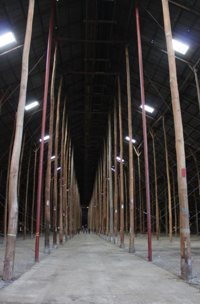
A shortage of steel meant that the shed was built largely from timber readily available at the time, most notably some 560 (56 rows of 10) bush-cut mountain ash poles erected straight into the ground. Some of the poles were 19-20 metres high. Concrete panels were then poured around the poles. The roof and walls of the Murtoa Stick are made of corrugated iron painted ferric red. Much of the building was done with little mechanical aid, and most of the workforce was away fighting overseas.
Constructing the Stick Shed
The “Murtoa Stick Shed” demonstrates Australian ingenuity during a time of hardship, it was constructed over a period of only four or five months, commencing in September 1941.
The side conveyor
Bulk deliveries of grain were distributed through the Stick Shed via a system of mechanical elevators and conveyors, including a central conveyor running high along the centre of the shed.
Elevators transported wheat from delivery hoppers up to ridge level where it was distributed by conveyor along the length of the shed, creating a huge single mound of grain. Braced internal timber bulkheads on either side of the shed took the lateral thrust of the wheat, and a conveyor at ground level outside the south bulkhead took wheat back to the elevator for transport elsewhere. The roof angle was sloped to reflect the same angle a pile of wheat forms naturally.
The shed is 280m long (the length of five Olympic swimming pools), 60m wide and 19m high at the ridge, and had capacity to store 95,000 tonnes (or 3.4 million bushels) of grain.
Deliveries of bulk wheat commenced in January 1942, and by June of that year the grain store was at full capacity.
The Marmalake/Murtoa Grain Store is the earliest and only remaining of three large sheds of an unusually grand scale of the Australian rural vernacular corrugated-iron tradition built in Victoria during the early 1940s.
Use of the No.1 shed and the larger No.2 shed, erected in 1942/43, continued for many years. (Original plans also included a No.3 Shed at Murtoa, but this was never completed.) The No.2 shed was demolished in 1975. The No. 1 shed was also becoming increasingly expensive to maintain, and its use was phased out by 1989.
 
The 560 unmilled tree trunks supporting the roofing timbers and iron of the Stick Shed might be viewed as a peculiar, symmetrically arranged “interior forest”. With its vast, gabled interior and long rows of poles the interior space has been likened to the nave of a cathedral.
When the Stick Shed ceased to be used for grain storage after 1989, plans were made for its demolition. However an Interim Preservation Order was served by Historic Buildings Council (HBC) in December 1989 and by December 1990 the shed had been added to the Historic Buildings Register. Debate continued over subsequent years, with frequent calls for the demolition of the building from some sources and persistent arguments for its preservation from others.

Netting over the ferric red roof
Ultimately, the Heritage Council of Victoria undertook a large-scale program of work to stabilise and repair the Stick Shed, including the repair of damaged poles and installation of galvanised wire “netting” to cover the entire roof area. Work is being undertaken to provide permanent public access to the Shed, separated from the activity of the surrounding grain receival complex. Application has also been made to have the Stick Shed added to the Commonwealth Heritage Register.
See the complete story with photos and video at the Culture Victoria site.

Thursday, 11 April 2013

Approaching milestone

Just a reminder, as time is drawing near for the Horsham Library’s guided walking tours of the Old Section of the Horsham Cemetery. Two tours will be run, the first – the Daytime Tour – will be 12:30-2:30pm, the second – the Night time Tour will be 6:30-8:30pm. Both tours will be conducted on Saturday 20th April 2013.

The two tours will concentrate on the Old Section of the cemetery, where the tour guide will highlight various headstones and graves depicting local community milestones of historical events and local identities.
The purpose of the tour is to promote the appreciation of the role of cemeteries and cemetery research in compiling family research and knowledge of local history.
Entry is via the Pioneers Entrance in Kalkee Road, with parking near the Cemetery Trust Office. 

Refreshments will be available after each tour.
Attendees will need to wear suitable clothes for the weather and enclosed comfortable footwear. Also those on the Night time Tour will need to bring a torch or lantern.


Bookings are essential for both tours, and will be taken at the Horsham Branch Library in the Mibus Centre, 28 McLachlan Street in Horsham 
(Phone 03 5382 5707, email horsham.library@wrlc.org.au).
Attendees are required to complete a Cemetery Tour Agreement form prior to undertaking the tour.

The “Milestones & Headstones” cemetery walking tours, are part of the 2013 National Trust Community Heritage Festival, 18 April-19 May 2013.

Monday, 8 April 2013

Journeys and arrivals

The Courier and the Themistocles outside the Port Phillip Heads
The National Archives are holding an Open Day on 16th April as part of their "Shake your family tree" programs.
The Victorian Archives Centre has information in their vast collection about many Australian families – possibly your own.
Many Australians are descendants of migrants. Learn how to find records to your family's story of arriving and settling in Australia.
If members of your family migrated to Australia in the 20th century, served in the defence forces, or worked for, or had any other dealings with, the Australian Government, then the Archives are likely to have something to interest you.
The National Archives will be showcasing their new website of more than 20,000 photographs.
At the Open Day, you can take part in a range of free activities including talks, demonstrations, conservation clinics, seminars, workshops and introductory research training.
For Program details, to book seminars.

Monday, 1 April 2013

Border clash

Seems the debate is back - South Australia is apparently attempting to argue for the Disputed Territory again.
Back in the 1800s when map makers were drawing up the state boundary between Victoria and South Australia, they made a wee mistake in their maths.
The area became known as 'The Disputed Territory' until in 1914 when it was officially made part of Victoria.
The most outstanding feature of the Territory is Serviceton and its railway station. Serviceton is the only town located in the Territory, it's reason for its existence was as a border crossing on the main interstate rail line. When the railway line was built from Melbourne to Adelaide, the Serviceton station was  paid for equally by both governments to provide a place for the exchange of locomotives and crews. It was the customs post on the incorrect state border, now it is firmly in Victoria - but for how long? 
The South Australian end of the Serviceton station
A tv crew from Today Tonight are filming a segment on the dispute at Serviceton, to be telecast sometime afterwards.

The border line on the Western Highway
The “Disputed Country” was a thin sliver of land between Victoria and South Australia. It lies between the 141st east longitude (intended as the border line) and a surveyed line approximately 3 km to the west of that longitude.
Following the establishment of the colony of South Australia in 1835, a survey of the South Australian - Victorian border from 1847 to 1850, (the Port Phillip District was created as the separate colony of Victoria in 1850) was a three-year struggle of dogged persistence through flooded swamps, then the waterless Mallee scrub and the almost immediate destruction of the border markers by a devastating fire.
In 1839 Charles Tyers was transferred from the Royal Navy to the Colonial Service, to ascertain the 141st meridian (the eastern border of South Australia). At the mouth of the Glenelg River at Nelson, he formed a broad arrow with limestone rocks. This became known as Tyers' Mark and was used to determine the starting point for the border survey. Due to his inadequate equipment this was later determined to be 3.3 km in error.
No action was taken to extend Tyers’ work, but by 1845 there were disputes with South Australian pastoralists working their way east from the coast meeting pastoralists from the Wimmera region pushing their way westwards with flocks of sheep. In November 1846 the Colonial Secretary's Office directed surveyor Henry Wade to proceed to the disputed territory to define a "Boundary for Police Purposes".

Border plaque, Western Highway

In March 1847 Wade’s party of seven and equipment, at the mouth of the Glenelg River, was joined by assistant surveyor Edward Riggs White (appointed by the South Australian government to act as an observer on its behalf). The expedition collapsed at the 36th Parallel in July, after nine months of swamp, sand dunes and broken equipment, deprivation and hardship due to drought, and reluctance by his men to continue with poor work conditions - still 250km short of the Murray River.
The two colonies agreed that White should complete the survey from “Wade’s Termination Point" is just north of the present day Bordertown, SA to the Murray. In August 1849 White and his party of five encountered the severe nature of the Big Desert. Where there was little water in 1847, but none two years later. Within two weeks his mutinous men had deserted White and two of his three horses died. On the verge of collapse, he managed to bleed the last horse and drink half a pint of its blood. Lost, he managed to stagger on for about two miles (3.2 km) to the riverbank at the border of three states and complete the survey.
Doubts as to the accuracy of the Wade-White line grew. Determining longitude back in the 1840s was imprecise owing to the lack of precision clocks. At the time, the assumed longitude for Sydney Observatory’s was in error by about 3 km. Since the Vic-SA border survey took the Sydney Observatory as its starting point, it too was in error.
The Sydney Observatory today
In April 1868 an expedition led by the NSW Government Astronomer George Smalley and Charles Todd the South Australian Superintendent of Telegraphs, led to the discovery that the proclaimed border on the ground was at least 3.6km to the west of the more accurate measurement of the 141st meridian.
However by 1849, 47% of the Disputed Territory had already been sold or leased out by the Victorian Government.
In February 1851 a gigantic firestorm (the bushfire as immortalised by William Strutt in his painting “Black Thursday 1851”) wiped out many of the timber border markers. Wade’s Line has been recovered with reasonable accuracy, but the location White’s Line has been lost ever since. Because the original survey books have been lost, and most of the original timber posts were lost to the fire, the location of the actual state border is not known, even today.

Strutt's epic 'Black Thursday 1851" at State Library of Victoria
Between 1883 and 1893 South Australia sought Victorian relinquishment or financial redress. At the peak of disagreement South Australia threatened to ‘invade’ Victoria and sub-divide the disputed country. But the Victorian government threatened to arrest any such invaders and the threat was not put into action.
South Australia finally abandoned all hope of settlement, due to Victoria's intransigence, and in 1911 it appealed to the High Court which dismissed the appeal. Eventually, in 1914, the Privy Council in London ruled in Victoria’s favour - that Wade & White’s line was the legal border, and £215,000 was awarded to South Australia as compensation for the forfeiture of 1,300 km2 of territory lost. But since the border markers were wiped out by fire the location of this line has been lost for 160 years. Complicating the re-survey of Wade & White's line is the loss of their original field survey books. So there are no detailed notes as to its location, only a few scattered "fixes" from other surveyors who came later.
The position of today's border is 2.96-3.35km west of 141 east longitude.
Historical information from "The disputed country : Australia's lost border" by Bob Dunn and  John Deckert (of Nhill's Westprint Heritage Maps).

Monday, 25 March 2013

Wimmera stories launch

Eleanor & Paula admire the displays

Three stories relating to the Wimmera region were launched at an event in Murtoa on Saturday.

The launch was part of the Murtoa Lions Club's Afternoon Tea function - a high tea to celebrate the beauty of years gone by, where guests were invited to come dressed in the vintage theme.

There were also lessons on correct dinner-table etiquette, antique appraisals and displays of object d'art, family handicrafts and heirlooms.

A cooperative venture with Culture Victoria, Heritage Victoria and the Library, the stories are now live on the Culture Victoria site.

Culture Victoria is an organisation dedicated to digitising and making available our cultural assets. The Culture Victoria site provides access to Victorian cultural collections through stories that showcase the richness and diversity of Victoria, and via a collections search facility across the websites and databases of Victorian acquisitive organisations and collections.
Malcolm editing the story images
Documentary film-maker Malcolm McKinnon, has been working with the local organisations involved with each story, creating a number of still photographs and short video, to be coupled with historic images to produce social histories on the local environment.

More on each story in the following posts.


Thursday, 14 March 2013

Cold cases

Have been working with a couple of local Historical Societies recently on some collaborative projects.
The Western Victorian Association of Historical Societies is about to celebrate its 50th anniversary, and members were searching for a number of missing copies of their journal the 'Western Historian', fortunately the Library was able to photocopy the relevant editions from our collection.

At the same time a number of people are researching a couple of unsolved murders, and are finding the digitised Australian Historic Newspapers on Trove invaluable.

And the unsolved murders? 
  • Firstly 'The Maryvale Murders' occurred in 1874, when Maria Cook with her young daughter Louisa, and an unknown man & dog were killed near the Sheepwash Reserve on Maryvale Station
  • Second 'The Gymbowen Mystery', where ex-schoolteacher, and recently married Mary Tierney was poisoned via strychnine in 1905
  • Finally a case with a verdict of suicide, but which "reeked with suspicion" according to the coroner - the death of 'the Gypsy Queen' Olga Toohey aka Olga Johan, at the Apsley Racecourse in 1931.
 Anyone with information on these cases is welcome to add their knowledge to the file.

Tuesday, 12 March 2013

Independent type

It was the end of an era, when Allan Lockwood died on Monday night. Allan was the last surviving son of newspaper pioneer Alfred Lockwood. Alfred purchased the West Wimmera Mail newspaper in Natimuk in 1899, and all his six sons grew up working and assisting with all aspects of producing the paper.
Allan, the youngest, was 13 when his father took him out of school to work on the paper (he was folding, wrapping & delivering papers while still at school) at the end of 1935. As an unpaid full-time employee, he set type, reported on meetings, operated the machines with his brothers. Allan joined the Army in 1942, and was at Noonamah when the Japanese bombed Darwin. Allan married Winifred Uebergang on 22nd April 1944.

Keith sharing a joke with Allan, 2009
After the war he returned to the newspaper in 1946. Alfred retired at the end of 1950, aged 83, and Allan and brother Frank took over, until the West Wimmera Mail and Natimuk Advertiser merged with the Horsham Times to form the Wimmera Mail Times in September 1959. The Wimmera Mail Times was established with Frank as manager, and Allan as its editor.
Allan continued at the Mail Times until his retirement in 1985, after which he and Win traveled, and Allan turned his hand to writing a variety of biographies and local histories.
They had eight children - Greg, Bruce, Peter, Keith, Rosemary, twins Miriam & Marion, and Kerry. The family lived in Natimuk, where Allan died on Monday 11th, aged 90 years. His funeral will be at St Paul's Lutheran Church in Natimuk on Tuesday at 10:30am.

Sunday, 3 March 2013

Field Days @ Longerenong

The Library will be at the Wimmera Machinery Field Days at Longerenong on Tuesday 5th, Wednesday 6th, and Thursday 7th, where there will be an exhibit of some of Andrew Chapman's photographs, which relate to farming.
Come and see the Library's site in the Moore Pavillion.