This month the State Library’s “Our story : Such was life” is ‘The Mallee’
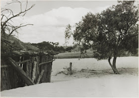
In Victoria’s north-west lies the Mallee; a dry, hot region featuring sand dunes, salt bushes, shrubs and a ‘strange dwarf gum tree, Eucalyptus
Dumosa, usually called Mallee…The tough land and climate certainly made an impression on Dr. Neumayer, a surveyor who recounted his experiences in 1864, ‘I can readily imagine why most people speak of this part of the country with a certain dread for there is actually no grass and no water to be found’…Over the years the land has endured its share of rural disasters, namely plagues
(rabbits, mice, grass hoppers), drought and dust storms. Today its 100,000 occupants mainly reside in major towns like Mildura, Swan Hill and Kerang, but the Mallee is also dotted with smaller towns with delicious names such as Patchewollock, Cowangie, Boinka, Underbool, Piangil, Walpeup and Manangatang…In 1995 the State Library received a collection of photographs from the Rural Water Corporation (State Rivers & Water Supply Commission) which span the late 19th century to 1980. The thousands of images document Victoria’s water use and include many from the Mallee and Wimmera, which feature in this post.
Unfortunately some of the records have little or no information attached,
they were grouped together under titles like: [Wimmera - Mallee District] [picture], or [Wimmera region] [picture] with Accession no(s) RWP/1855; RWP/1870; RWP/1884; RWP/1883;RWP/1906; RWP/1862; RWP/1873; RWP/1926; RWP/1895; RWP/1932; RWP/1881; RWP/1878;
RWP/1871; RWP/1872; RWP/1896; RWP/1923; RWP/1860
And Summary Descriptions: Shows sand drift on a Mallee farm, crops on Mr. Black's property, sheep at drinking storage at Dumosa, crops near
Murtoa, ploughing at Murtoa, Miss Lodwick in her father's vegetable garden at Timberoo, interior of wheat storage shed in Murtoa, abandoned homestead at Galah, horses drinking from bore-water trough, Consolidated State School at Murrayville, bowling green at Ouyen, sand and crops at Patchewollock.
For some, it is easy to positively identify - for example the 'ploughing at Murtoa' can only be the 'RWP 1870' as the Stick Shed is visible in the background.
 |
| Ploughing at Murtoa (RWP 1870) |
Likewise 'interior of wheat storage shed in Murtoa' is 'RWP 1884' a great shot of inside the Stick Shed.
 |
| Interior of wheat storage shed in Murtoa (RWP 1884) |
It gets trickier with descriptions like 'abandoned homestead at Galah'. This is possibly 'RWP 1883' if you consider the building to look abandoned or derelict. Galah was a siding on the way to Walpeup.
 |
| Possibly abandoned homestead at Galah, it is RWP 1883 |
Another photograph which could be 'crops near Murtoa' or 'crops on Mr. Black's property' is 'RWP 1855'. Mr Black's property was at Timberoo - north of Patchewollck and south east of Walpeup, and south west of Ouyen. Looking at the health of the crop and the vegetation in the background, it looks more like the Wimmera, than a really good year in the Mallee.
 |
| RWP 1855 |
From another catalogue record comes this graphic photograph, likely to be - 'wind erosion and sand drift at Patchewollock' and the gentleman, one of the commissioners - McClelland, Greenwood, Stafford, McNab, Fitzgerald, Hall, Rogerson, Welch, Godkin or East. It was taken during Royal Commission on Water Supply in 1936.
 |
| RWP 589 |


No comments:
Post a Comment