Thursday, 18 December 2014

On the stage in Watchem

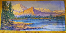
Back in August 2013 the blog entry ‘Drawing the curtain’  related to stage curtains, the section of the stage which sets the scene. These backdrops were works of art, huge canvases often depicting rural/garden scenes or town/cityscapes. 

One of the most prolific artists of stage curtains in Victoria was scenic stage painter Barry Henry George Jaggers (1869-1940). Originally from New Zealand where he painted over 80 public concert halls, he was engaged by the government of New South Wales to decorate public buildings for the Commonwealth (Federation) celebrations.
Moving to Victoria, Jaggers painted a number of scenic backdrops for Mechanics' Institutes in Gippsland, and Central Victoria. And as we’ve just found in Watchem too.
Below is the stage curtain he painted in 1928 – “In the Rockies”, which is still in use in the Watchem Public Hall.

Sunday, 14 December 2014

Photos up north

The magnificent Catholic Church building at Watchem
The next 'Wimmera in Photographs' Collection Day is Thursday 18th December, in the morning, sessions will be held in the Birchip Library from 10am to 1pm, and during the afternoon at the Watchem Hall from 2:30 to 4:30.
This is a chance for people in the southern Mallee to bring in photos, slides or negatives which showcase the history of the district. It would be great to see images from localities like Kinnabulla, Watchupga, Jil Jil, or Curyo - old school and railway sites, etc.
Appointments are necessary, and can be made by calling in to the Birchip Library at the Birchip P-12 College or phoning 58492 2230.

Tuesday, 9 December 2014

1914-1918 news

A major project commemorating World War I has digitised 216 World War One-era Victorian community newspapers and made them available online via the National Library of Australia’s Trove portal. 


Victorians everywhere can now explore the stories of their communities and family and friends who lived and fought through the Great War.
This digitised collection contains thousands of stories waiting to be found. These newspapers of the day provide, in their original format, news and public debate; letters from soldiers, sailors and nurses; death notices, images and more.
The newspapers can be freely and easily searched by anyone at anytime and anywhere, using keywords, dates or geographical regions
The digitised newspapers cover the period 1914–19. Many soldiers were still being demobbed in 1919, and mentions of celebrations for returned soldiers can be found in papers of this time. Also, many in memoriam notices can be found in papers the year after a soldier died.

.
The collection includes Wimmera and Southern Mallee papers: Birchip Advertiser & Watchem Sentinel, Hopetoun Courier & Mallee Pioneer, Horsham Times, Nhill Free Press, Rainbow Argus, St Arnaud Mercury, Stawell News & Pleasant Creek Chronicle, Warracknabeal Herald, West Wimmera Mail & Natimuk Advertiser, and more general papers - Stock & Land, and Weekly Times.
The digitisation of these newspapers has been supported by the State Library of Victoria, National Library of Australia, Public Libraries Victoria Network, local councils and historical societies.

Wednesday, 3 December 2014

In Love with the cottage

Love’s Cottage and its outbuildings, in Clyde Street, St Arnaud represents one the oldest miner's properties in the town. 


The single storey, modestly scaled, Victorian vernacular cottage is characterised by a double gable roof with no eaves, clad in galvanised corrugated iron. The original stone wall construction has been surfaced with cement render possibly in the 1940s (except for the rear wall). Two cement rendered and brick chimneys adorn the roofline. The timber framed six paned windows appear to be early, with the timber framed double hung windows at the rear introduced at a later stage. The vertical boarded front door also appears to be early. Internally, the walls and ceilings vary in materials and finish from whitewashed plaster to galvanised iron and paper on hessian. exposed remnant stone wall construction.
The combined stables & boy's sleeping area

The outbuildings on the property include a blacksmith's shop, which has collapsed and is in ruinous condition. It has a gable roof form clad in galvanised corrugated iron, and remnants of bush pole structure and sawn hardwood weatherboard wall cladding.
An external toilet is situated nearby the stables and has a simple gable roof clad in galvanised corrugated iron, with early horizontal weatherboard wall cladding and vertical boarded door. It is in a perilous condition and has almost collapsed in upon itself. Other remains of small structures include a mud brick goose pen and a timber kennel.The gardens on the property reflect its layout and many early plantings, including fruit trees, agave, phlox and agapanthus still endure.

The cottage was originally built in 1868 with layers of flat stones and rubble (from a nearby mine) between timber posts, the walls are at least 12” thick. In the 1940s the external walls were surfaced in cement render. Originally a two room cottage, it was constructed by John Tyson with assistance from William Thompson. 

A kitchen and adjacent room with packed earth floors was added, and more recently a laundry and toilet annexe added to the rear. The Tysons raised 11 children on the property. 
In 1896 the property was owned by Robert and Eliza Love and their family of nine, who built a blacksmith's forge, stables and an outside toilet in the early 1900s. In 1985, following the death of Ethel Love, daughter-in-law of Robert Love, the property was bequeathed to the National Trust of Australia (Victoria) and classified on the historic register in 1986. In 1987 responsibility for the property was given to the St. Arnaud Historical Society.

Monday, 10 November 2014

Dressing the set

Work is progressing on filming for 'The Dressmaker' movie.
Here are a few snaps from the film's Pinterest account - glimpses of on-set life during the creation of the Dressmaker film.
The new & the old - Director Jocelyn Moorhouse and Director of Photography Don McAlpine prepare for the very first shot of the film

Molly's house - erected inside the filming studio

 Capturing the shot - Production Designer, Roger Ford, & director, Jocelyn Moorhouse, in the interior of the Pettyman's house

Looking authentic - the Pettyman's kitchen

Grand opulence - the front room of the Pettyman's house

Author of the book - Rosalie Ham will be at the Horsham Library at 7:30pm on Monday 8th December.
Bookings are essential for this chance to hear from the creator of the story herself - Phone the library on 5382 5707 or drop in to the library before the 5th December.

Thursday, 6 November 2014

Wot's in a name

What is in a name, its spelling, its pronuncation or its meaning, and how do these change over time?
The original gateway to North Brighton (the posts are over 5' high)
While out touring on the weekend there was some lively discussion as we drove along Mokepilly Road near Kewell - on how it was the same spelling as the other Mokepilly near Stawell.
Sure that it was Muck rather than Moke originally, I couldn't let it rest, so cranked up the PC to check out the Duffy map (PROVs online version of The 1862 Duffy Land Act map) fairly sure it included Muckpilly as an out-station of the Kewell Station. I was half right, the out station was "Muckbilly". 
Kewell Station was named as "Kewell or Muckbilly" and "Kewell & Muckbilly", it was settled by the Wilson brothers John & Alexander in April 1845.
And in fact the Mokepilly of Lexington Station is also spelt Mokepille in some sources.
The other bone of contention was the correct pronunciation of Darlot (of James Monckton Darlot fame) was it the French "dar-low" as with Darlot Swamp or the more common vernacular "dar-lot" as with Darlot Street. I think it is the old-timers who like to use some class and refer to the original dar-low while the lazier Aussie speech is sounding more a chopped-off dar-let.
Darlot settled Brighton with Archibald McLachlan in July 1843. It was subdivided into North and South Brighton in 1859.
The tour included a number of historically significant sites - the Kewell area, the entrance to North Brighton, and the remains of the Dooen Weir on the Wimmera River. 
Looking downstream of the Dooen Weir

Tuesday, 28 October 2014

The way we were


The library's latest project is “The Wimmera in photographs – the way we were”. The Wimmera Regional Library is collecting copies of local photos to create an online photo album of our Region.

The library is searching for photographs of towns and rural communities of the Wimmera and Southern Mallee.

Image: The Donald Water Tower under construction in 1887. It was demolished in 1918 and the site became the ladies croquet green (Museum Victoria)

These images are a unique and highly significant historical resource, and provide insights into domestic and working life, education, recreation, travel, settlement and much more.
The project aims to visually record and document the history and culture of this region using photographs from family collections.
The criteria for selecting images is that they contain images of significant buildings, streetscapes or representative scenes – facilities which no longer exist eg.  flour mills, breweries & cordial factories.
Exclusions include current scenic pictures – which are more the province of Flickr, Instagram & Facebook. Family portraits lie outside the scope of the project.

 Image: Neighbours helping Tom Lynch's widow harvest a crop in the Warracknabeal district, c1915 (Museum Victoria)

To create the collection, library staff will copy each image and its details on a worksheet. The originals can either be returned to its owner, or donated to the library. 
All images in the collection will be digitised and searchable on the Library’s website — www.wrlc.org.au  The images will also be harvested by the National Library of Australia and will be searchable on their Trove site—trove.nla.gov.au

All images (unless otherwise stated) will be licensed under an Attribution-NonCommercial-NoDerivs licence. This licence allows others to download the image/s and share them with others as long as the credit you. The image cannot be changed in any way or used commercially.
 Image: The former St Michael's & St John's Catholic Church in Horsham. Built in 1913, the gothic style building was demolished in the 1990s (Heritage Victoria)

An idea of what we envisage for the project is our Pinterest account - http://www.pinterest.com/wrlcv/ - which is a collection of what already exists online, and we are looking at complementing that collection with “The Wimmera in photographs – the way we were”. (All images on this post are from our Pinterest account ).

The Launch of the project and its first Collection Day will be held at the Warracknabeal Library from 10am to 5pm on Wednesday 5th November. People wishing to have their prints, slides or negatives added to the "Wimmera in Photographs" Collection should book an appointment by visiting the Warracknabeal Library or phoning 5398 1270.
Image: a 1874 Beyer Peacock pattern "T" class locomotive, number 125 shunting at the flour mill siding in Natimuk, The loco was scrapped in 1918 (Winkieg)

Tuesday, 30 September 2014

Top award for the Stick Shed


Local icon - the Murtoa Stick Shed - is being placed on the National Heritage List next to natural places such as the Uluru-Kata Tjuta National Park and the Great Barrier Reef; other built heritage places - the Sydney Opera House, Port Arthur Historic Site, and Melbourne’s Royal Exhibition Building, and alongside our other local listing – the Grampians.


Australia's national heritage comprises exceptional natural and cultural places that contribute to Australia's national identity and encompasses those places that reveal the richness of Australia's extraordinarily diverse natural heritage.
This is Australia’s highest heritage honour, The Stick Shed, becomes just the 101st place of Australian cultural significance to be National Heritage listed.
 
The Stick Shed (The Marmalake No. 1 Grain Store) was born out of desperation and inspiration. Initially a temporary emergency building, it was erected during 1941 when the war prevented exporting the wheat harvest overseas. The Australian Wheat Board was left with a valuable resource a huge stockpile of grain, but insufficient, adequate storage for it.

Work started in September 1941 on a building designed to hold over 3 million bushels (92,500 tonnes) of wheat. The design was based on the same angle a pile of wheat forms naturally. Nearly 600 unmilled hardwood poles were used to hold up the roof.
The wartime restrictions meant that only raw, local and recycled materials were available, labour and machinery were scarce. Builders had to rely on ingenuity to overcome problems and shortages, they adopted common bush techniques to brace the poles.
What the builders erected was an adequate storage facility which has outlived its intended lifespan, but they also unintentionally created a serene cathedral-like interior amongst its forest of poles.  


Federal Environment Minister Greg Hunt said National Heritage listing meant the grain store was recognised as a significant part of Australia’s history and ensured it would be protected and celebrated for future generations. 
The Stick Shed is open this weekend on Saturday and Sunday from 10am to 4pm, as part of Muroa's Big Weekend - don't miss Australia's 101st National Heritage Site.

Wednesday, 3 September 2014

What's on the For Sale sign?

Historic property Kout Narin is for sale. An interesting aspect is the variant spellings of Kout Narin, from - Koot Narin, Koot Nareen, Kout Norien, Court Nahring, and the homestead area as Second Kout Narin.
The homestead in 1980, from the National Trust
Kout Narin on the banks of the Glenelg River near Harrow was originally taken up in 1840 by Thomas Norris as a 400,000 acre pastoral run. This was one of the largest of the early pastoral holdings in the colony at Port Phillip.
Edward Willis & Charles Lambert Swanston (Charles’ father and Edward’s father-in-law was Captain Charles Swanston a colonial merchant and banker after whom Swanston Street in Melbourne was named) acquired Kout Narin station in October 1846 as ‘The Glenelg River Grazing Company’. Later in April 1848 they subdivided it into Kout Narin and Kadnook. (Kadnook was subdivided into Kadnook and Buckle Kupple in August 1857, then Kadnook further broken up into Kadnook and Tallangour in August 1864, Tallangour was divided into Tallangour and Lake Paddock in April 1874.) Kout Narin was further subdivided in September 1852 into Chetwynd and Pigeon Ponds (Moree) and again in September 1859 divided into Chetwynd, Mooree (or Pigeon Ponds), Koolomurt and Wellat(t). Willis and Swanston retained a part known as Koolomurt in 1859. Swanston kept Mooree in 1859. At Koolomurt, Willis formed one of the finest merino studs in Victoria. 
The Woolshed above Salt Creek, 1974 from SLV
Second Kout Narin was part of the original Rickett’s Run or Longlands. It was first occupied in April 1840 as ‘The Glenelg Sheep Establishment’. Thomas Rickett occupied it from 1843. Ricketts Run was broken up into Clunie, Longlands and Second Kout Narin. Second Kout Narin was on the right bank of the Glenelg. A two-room slab house with a shingle roof was erected in 1846.
The original slab cottage in 1980, from the National Trust
 In 1855 Richard Brown Broughton leased Kout Narin Station from Thomas Hamilton, where he subsequently erected the woolshed and the colonial homestead, integrating the early stone house of c1848. Broughton got the freehold for the Second Kout Narin property in June 1863. He changed the name from Kout Narin to Kout Norien.
From the curving driveway towards the rectangular house with a shallow flight of steps leading up to verandah, past garden beds, taken by an unknown photographer some time during the 1960s, copyright is undetermined, from SLV
 The early colonial style rectangular plan homestead of brick and stone with distinctive roof form, glazed verandah and colonial regency details was built in 1855 with the second storey portion added at a later date. The stone was quarried on the property. The homestead was placed on the Victorian Heritage Register in 1959, and the outbuildings added in 1980.
The stone-rubble stables with latticed openings, 1980 from the National Trust
The stone-rubble cookhouse, 1980 from the National Trust
Enclosed homestead verandah


The associated outbuildings, slab hut and slab woolshed, form an important pastoral station group, and are examples of early vernacular construction methods.


The following set of photographs was taken by John Collins in the 1970s, and are from the J.T. Collins Collection, La Trobe Picture Collection, State Library of Victoria.

The homestead
The homestead showing the quoins around the doors
The timber slab woolshed and its split picket sheep yards with the pickets wired together. Although dilapidated the woolshed is still in use.

The stone-rubble cookhouse and adjacent meat-house
Kout Narin is to be auctioned on Friday 12th September in Hamilton and is expected to reach $1.3-1.5 million.

Monday, 1 September 2014

Footprints to the Wimmera

‘Footprints: the journey of Lucy and Percy Pepper’’ is an exhibition by Public Record Office Victoria that uses public and family records to trace the lives of an Aboriginal family in country Victoria in the first half of the twentieth century.

 
Percy & his family, c1912, from the Watkins family
It focuses on the life of Percy Pepper. Missing two fingers following a work accident, Percy with his sick wife Lucy try to make a life for themselves and their seven children, while constantly on the move across Victoria in search of work. Deemed half-castes and thereby precluded from living on Aboriginal missions, the Peppers endured constant hardship.
Original letters, photographs and public records reveal a family plunged into poverty; their attempts to 'make good' and catch a break in white society frequently thwarted.

One of about 40 Aboriginal men who enlisted in the First World War, Percy fought in France where he sustained head wounds in a shell blast. Following his discharge he was one of the few Aboriginal soldiers to secure a soldier settlement block – and with it the hardships faced by many soldier settlers.

The Pepper family's generational story is one of hardship and resilience, of sorrow and loss – and a remarkable parable about the strength of family in the face of adversity.

The exhibition has special significance in the Wimmera, as Percy’s father Nathaniel Pepper had lived on the Ebenezer Mission at Antwerp. 
The ‘Footprints’ exhibition will be on display at the Dimboola Library and Dimb-E Shop in Lloyd street from Thursday 18th till Tuesday 30th September. 
An official opening will be held in the R.S.L. Hall in Lloyd Street on Wednesday 17th September at 7pm. (RSVP to Dimboola Library Ph: 5391 4452 by 12th September)

Wednesday, 27 August 2014

Lost again

"Child lost on Goolumbulla" is a poignant depiction of a quintessential Australian story of a helpless child lost in the bush, and the flurry of fear, hope and energy in the ensuing search. It is a forlorn but absorbing excerpt from "Such is life" written by Joseph Furphy in the 1890s.

"Such is life : being certain extracts from the diary of Tom Collins", is the splendidly farcical, tragical reminiscences of Tom Collins, philosopher and rogue (the author Tom Collins is a known pseudonym of Joseph Furphy). As Tom drives his team across the plains of the Riverina and Northern Victoria, he gets wildly entangled in the fate of others, recreating the humour, the pathos, the irony he knew as part of life in the bush. His is that tough-talking, law-dodging world of the 1880s, where the swagmen and bullockies slept out under the stars with 'grandeur, peace and purity above; squalor, worry and profanity below'. These inspired yarns, 'fatally governed by an inveterate truthfulness', are woven into one of the greatest books of Australian literature, combining a genius for story-telling with a wry wit and a deep feeling for the harsh sun-baked land and the people who worked it. "Such is life" is a classic of the Australian Outback.
 The story of "Child lost on Goolumbulla" is based on just one scene from "Such is life", but that one scene has produced a short film and an audio. They were gifted to the Library by
Andrew Furphy (who was prompted by the recent "Lost in the Bush 150th anniversary), a direct descendant of Joseph Furphy, the motivator of the idea and producer of the film The audio and the film are beautifully narrated by John Derum who also acted in the film. Shot on Thelangerin, near Corrong, (just down the literary road from
'Banjo' Paterson's Hay and Hell and Booligal) north of Hay in N.S.W., the film evokes that vastness of the Outback.
'One Tree Plain' & the road to Corrong

Wednesday, 20 August 2014

Lost in the Bush events Day10 (Sunday 21 Aug 1864)

A series of posts chronicling the daily experiences of the 'Lost in the Bush' children

The Lost story doesn't end at Day 9 when the children were found, there was a transition period as they recovered.  
On Sunday 21st they were taken to their parent’s hut about 16 miles away. The trackers were given money by a squatter and by Duff. The children were treated by Dr Archibald McDonald from Horsham who visited 22 hours after they were found. On the third day after they were found Rev. Patrick Simpson the Presbyterian minister accompanied Dr McDonald. It was from this visit that we get the best firsthand account of what happened, as Rev. Simpson wrote a letter to The Weekly Times & Messenger which was printed on 10th September 1864.
As a postscript it also contains a letter from Dr McDonald which details the children's conditions in medical terms: 
'on my arrival at “Spring Hill”, I found the children, who had been lost for nine days and eight nights, did not require much attendance from me. So judiciously had Messrs Smith and Wilson acted, and instructed those who had charge of the little wanderers, that I had but to recommend a continuance of their system of treatment. I found the children much emaciated, their eyes unnaturally bright, and their cries for food incessant. Although this was about twenty-two hours from the time of their being found, their expression of countenance and eager requests for food were very painful to those around them. Their pulses ranged from 120 to 140, being small and jerky ; their tongues were coated with a yellow fur, which remained for three days ; their little feet showed many deep wounds from the chafing of their boots and their legs were covered with scratches from the prickly heath through which they had travelled. About midnight they fell asleep, and slept soundly for six hours, and on awaking, appeared much improved in strength, and were not so clamorous for food. Since then they have progressed favourably, and on the 24th, when I last saw them, had so far recovered, that a little attention to their diet was all that was required.'

Tuesday, 19 August 2014

Lost in the Bush events Day9 (Saturday 20 Aug 1864)

A series of posts chronicling the daily experiences of the 'Lost in the Bush' children


Early on Saturday 20th Wilson, Duff, and Kenna his stepson resumed the search where Wilson had left off, and were assisted by the trackers. The superiority of the Aborigines was apparent, and the search continued at a much more rapid pace as the trackers read off the signs of the children's journeying. It was the trackers who found where the children had slept, had fallen in the dark, and with failing strength were unable to carry Frank.

Searchers approached a rise resembling the one near the station, they guessed the children would make for it, and on the further side before a vast ocean of dark and dreary heath stretching to the horizon, they found discarded broom tied with rope.
About 3pm Wilson saw fresher tracks crossing their trail like an X, he called to the trackers who corroborated his view, thereby saving 3 days tracking, within a mile they came across a clump of stringy-bark saplings where the children had spent the previous night.
Duff and Wilson both rode ahead at times. It was approaching sunset when Duff rode ahead of the other searchers to higher ground and saw a clump of saplings, closer he saw a covering moving in the wind and found the children asleep, Frank in the middle wrapped in Jane’s dress. The arrival of the others woke the children, Isaac attempted to sit up and speak but could only groan feebly “Father” and fall back. Frank asked why they had not come sooner. Jane could not open her eyes, only murmured “Cold, cold”. They had walked over 4 miles on the final day.
Emaciated, weak and barely able to speak the children were given crumbs of bread and taken to a waterhole where they were much revived before proceeding to the nearest hut 8 miles away, where they were reunited with their mother about 8pm. Putting the children to bed, Jane was heard saying her prayers as she had each night.

 
The waterhole as it is today, at the Nurcoung Bushland Reserve

Monday, 18 August 2014

Lost in the Bush events Day8 (Friday 19 Aug 1864)

A series of posts chronicling the daily experiences of the 'Lost in the Bush' children

On Friday 19th the children had been missing for a week - spare a thought for their mother Hannah who has been waiting at home for word of the children. 
Alexander Wilson, the squatter, joined the search. Alexander was born in Antrim, Ireland in 1820 and emigrated to Australia in 1839 (Rev. Simpson described him as "a man of great colonial experience and remarkable acuteness").  It is unknown where he had been for the previous week. At the time the Wilsons had a number of properties, and Longerenong & Ashens were both a couple of days ride away. It was also in 1864 that Alexander had the grand 2-storey Vectis homestead constructed.
Vectis homestead 1864-1935 (SLV collection)
Before the day was far advanced, Alexander Wilson found and followed a track slowly but surely, often on his hands and knees, pegging as he went, so that the track might afterwards not be lost . 
The party returned from Mt Elgin during Friday night (variously referred to as Dickey, Jerry & Fred or Dickey, Red Cap and Tony).

Sunday, 17 August 2014

Lost in the Bush events Day7 (Thursday 18 Aug 1864)

A series of posts chronicling the daily experiences of the 'Lost in the Bush' children

On Thursday 18th the men again searched in vain for tracks of the children.  In desperation, one of the men rode north to near Mt Elgin station approximately 30 miles away on the other side of the Little Desert to recruit black trackers. 
Different versions of the story have either Duff himself riding to Mt Elgin, or Peter McCartney of Nurcoung as the man who knew of the trackers and offered to bring them back. Either way, it was our 'Paul Revere' ride - 60 miles on horseback through desert, some of it in the dark.
***
With the large crowd out at the Memorial site yesterday (17th August 2014) for the Community Afternoon Tea, it is fitting to include here a description of the original unveiling of the monument - 
A worthy recognition of one of Australia's heroines, Jane Duff, was made on Friday at Nurcoung before a large gathering. The brave act of the young girl is now a matter of Australian history, but the younger generation has since thrilled to the deed of a little girl in the long ago.
Fine weather attracted 800 people, principally from Natimuk, Goroke, Gymbowen, Nurcoung and Mitre. From 1:30 to 3 p.m. a programme of children's sports was keenly contested. A working bee of Natimuk citizens had prepared the ground on Thursday and the result was an excellent running track. The road was beflagged at, approaches from Natimuk and Goroke and flags were put on the trees on the reserve to form a circle for the ceremony. Everybody was delighted with the function, which proved a great success and a fitting climax to a brave deed.
From the front page of 'The Horsham Times, Tuesday 30th April 1935.